Hope of Israel Ministries (Ecclesia of YEHOVAH):
Is Jebel Musa the CORRECT Mt. Sinai?
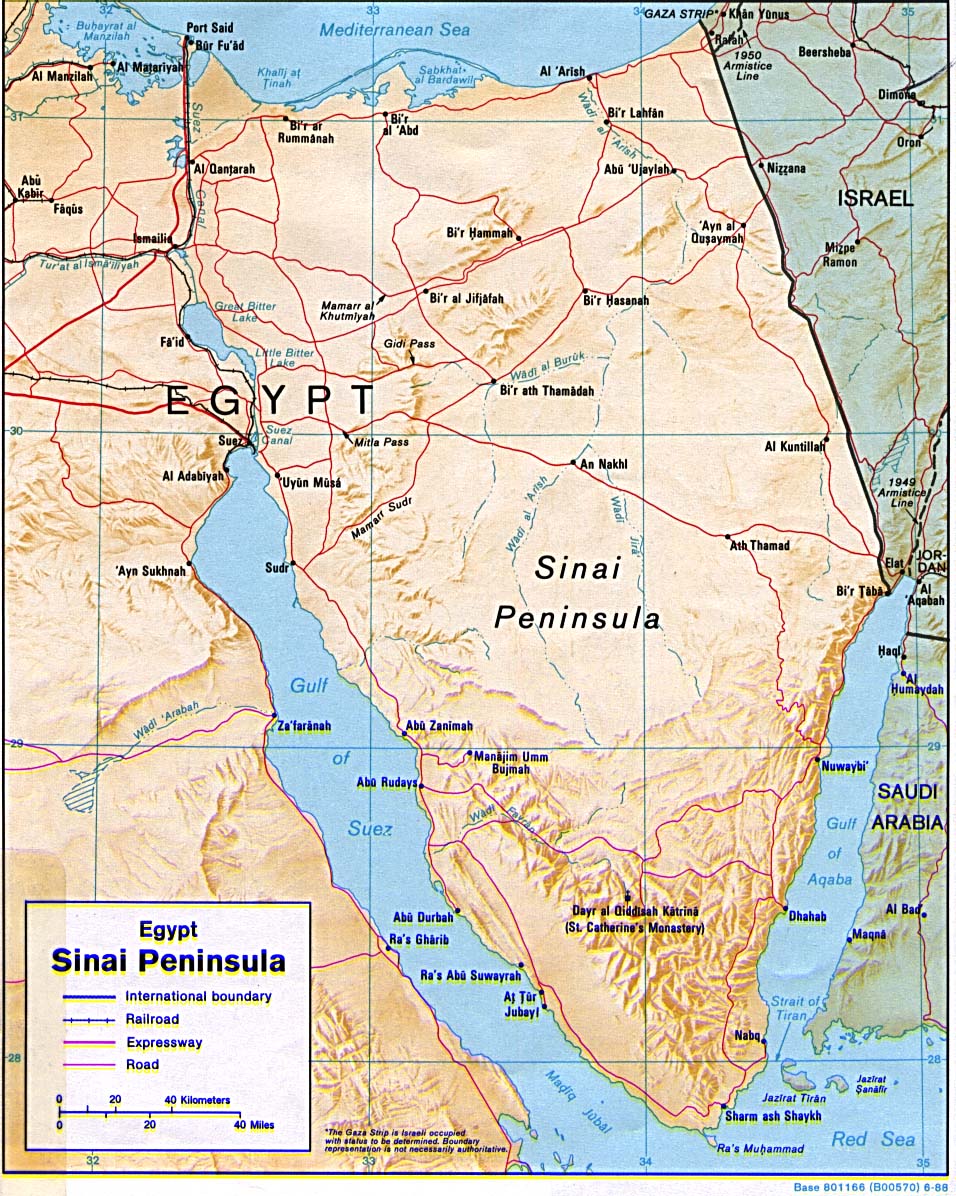
When Queen Helena, mother of Constantine the "Great," chose Jebel Musa in the Sinai Peninsula as the site of the Biblical Mt. Sinai, the Christian world blindly assumed this to be true! Every year excited tourists climb the slopes of the so-called Mountain of God, photographing Elijah's cave and the monastery of St. Catherine -- totally unaware that the REAL Mt. Sinai lies across the Gulf of Aqaba in the ancient land of Midian! How could this be? |
by John D. Keyser
It has become customary since the time of Constantine the Great for the majority of the Christian world to accept the area of the Sinai peninsula for the location of the biblical Mt. Sinai. Unknown to most, the REASON this location was selected rests solely with the opinions of one man -- the Roman emperor Constantine the Great (c. 280-337 A.D.)!
The question is, did Constantine select the correct spot? What prompted him to pick the rugged, mountainous region of south-central Sinai? The answers to these questions may surprise you!
The truth is, there was not the SLIGHTEST biblical or historical evidence to sustain the selection of this site as the proper place for the giving of the Law. In fact, just the OPPOSITE was the case, yet Constantine's opinion prevailed while he remained alive -- and is paramount to this present day.
What we must understand is that Mt. Sinai in the Sinai peninsula was selected exclusively through the agency of DREAMS AND VISIONS that Constantine experienced throughout his troubled life. Constantine had a LONG HISTORY of visionary experiences. From the year 312 A.D. they became a REGULAR part of the emperor's life; and throughout his career he was affected by FREQUENT SUPERNATURAL OCCURRENCES. And, according to Constantine himself, he never had a reversal in his affairs if he HEEDED these visions.
The beginning of his trust in the SUPERNATURAL occurred just before the battle at Milvian Bridge outside Rome, which gained for him the mastery of the western portion of the Roman Empire. As the story goes, he witnessed (along with his troops) a parhelion (a bright image appearing on a solar halo) of the sun which appeared to him as a CROSS in the heavens. With the cross he noticed the Greek letters Chi Rho accompanied with the words "by this sign conquer." The following evening he supposedly had a VISION of Christ who told him to adopt the sign of the "Chi Rho" as a symbol to protect him and his armies, and that he would ALWAYS be victorious. It was this so-called (by Constantine) "supernatural sign" that moved the emperor into thinking he had been DIVINELY SELECTED to bring about a UNIVERSAL KINGDOM that would usher in divine salvation and peace to the world.
According to Ernest L. Martin: "This visionary experience had a profound effect upon Constantine. In the following years he featured himself as the DIVINELY CHOSEN instrument of God to bring in the UNIVERSAL (CATHOLIC) KINGDOM TO THE TOTALITY OF THE WORLD. It gave Constantine great confidence that he was a special and elect vessel of God himself. And in all the battles that Constantine fought from A.D. 312 onward, with what he called the salutary sign of the "Chi Rho" in the advance of his armies, convinced him that he was indeed that special person selected by God to bring to pass the universal kingdom of Christ on earth" (Secrets of Golgotha. ASK Publications, CA, p. 99).
It appears that not long after his visionary experience at Milvian Bridge, Constantine began to think of himself as a NEW MOSES ordained by YEHOVAH God to lead the true people of YEHOVAH into a NEW WORLD ORDER with Constantine as its head. To reinforce this identification with Moses, Constantine had a SPECIAL TENT constructed in the form of a cross which he, LIKE MOSES, placed "outside the camp." (Ex. 33:7). It was into this tent that he and his trusted advisors would enter before any military action to seek "divine counsel" to direct them in the upcoming engagement.
Eusebius -- church historian and scholar of the third and fourth centuries -- noted what usually happened when Constantine entered this tent: "And making earnest supplications to God, he was always honored after a little while with a MANIFESTATION of His [God's ] presence. And then, AS IF MOVED BY A DIVINE IMPULSE, he would RUSH from the tent, and SUDDENLY give orders to his army to move at once without delay, and on the instant to draw their swords. On this they would immediately commence the attack, fight vigorously, so as with incredible celerity to secure the victory, and raise trophies of victory over their enemies" (Life of Constantine, II. 12).
These "divine impulses" ruled Constantine's life. Eusebius noted that Constantine's visions and supernatural encounters became such an ingrained part of his affairs that "a THOUSAND such acts as these were FAMILIARLY AND HABITUALLY done by the emperor" (Ibid., II, 12 & 14). Constantine's WHOLE LIFE was filled with visions, dreams and supernatural wonders; and they became FOREMOST in ALL his major decisions!
"This was," notes Michael Grant, "an epoch...in which VISIONS were frequently and continually seen, or imagined to be seen, by all and sundry, especially at decisive turning points of history, and it was natural enough for someone who had played such an important part as Constantine to believe, or require others to believe, that he, too, had seen a vision, which supported his [supposed] adherence to Christianity" (Constantine the Great: The Man and His Times. Charles Scribner's Sons, N.Y. 1994, p. 138).
"The ancient world," continues Grant, "and especially the world of Constantine's epoch, was as credulous of significant nocturnal DREAMS as it was of other kinds of VISIONS. 'It is to dreams,' wrote Tertullian, 'that the majority of humankind owe their knowledge of God.' Artemidorus of Ephesus devoted a study to the subject, the Oneirocriticon. Divine powers were believed to visit people very often in their dreams and give them messages, and this was thought to apply particularly to great and powerful men. Thus an angel was said to have appeared in a dream to Licinius, and Constantine himself was said to have seen and talked with God in dreams, as part of his LIFELONG RELATIONSHIP WITH THE SUPERNATURAL" (Ibid., p. 140).
And there was NO EXCEPTION TO THIS when Constantine selected Jebel Musa in the Sinai peninsula as the "true" site of the Mountain of YEHOVAH God. As we shall see, there was no biblical or historical teaching that prompted Constantine to pick the area in the wilderness of the Sinai. The Jews themselves had NO FIRM TRADITION regarding the location of Mt. Sinai.
Notice what the Jewish Encyclopedia says:
There is NO Jewish tradition of the GEOGRAPHICAL LOCATION of Mt. Sinai; it seems that its exact location was OBSCURE already in the time of the monarchy....The Christian hermits and monks, mostly from Egypt, who settled in Southern Sinai from the second century C.E. on, MADE REPEATED EFFORTS to identify the locality of the Exodus with actual places to which the believers could make their way as pilgrims. The identification of Mt. Sinai either with Jebel Sirbal near the oasis of Firan (Paran; Nilus, Cosmos Indicopleustes), or with Jebel Musa, CAN BE TRACED BACK AS FAR AS THE FOURTH CENTURY C.E. [TO CONSTANTINE'S TIME]. (Vol. 14, p. 1599).
The selection of the Sinai peninsula for the site of Mt. Sinai probably occurred at the same time Constantine decided to build a church at the supposed place of the Messiah's resurrection in Jerusalem. The identification of "holy sites" in the Middle East was the result of an ATONING ACTION by Constantine for the deaths of his wife Fausta and his son Crispus -- executed at his own command. In a fit of depression Constantine sent his MOTHER HELENA to the Middle East to discover the spots he had "foreseen" in his visions.
The strange thing is that almost all of the spots that Helena "identified" as holy sites were previously occupied by some sort of PAGAN structure! "The very place where Jesus himself was believed [according to Constantine's "dreams"] to have met his death and to have received the burial that preceded his Resurrection: the Church of the Anastasis or the Holy Sepulchre on Mount Golgotha, [was built] upon the site of a Jewish burial chamber and beneath A TEMPLE OF APHRODITE" (Constantine the Great: The Man and His Times, by Michael Grant, p. 202).
Not only that, but while Helena was in Palestine she ordered a church to be built on the spot where the "cross of Christ" supposedly had been buried! In order to find the "cross," "she had made inquiries among the local people, who advised her to proceed to a place where 'ancient persecutors' had built A SHRINE OF THE PAGAN GODDESS APHRODITE. STIMULATED BY VISIONS, she ordered that the site should be excavated, whereupon, according to St. Ambrose's work On the Death of Theodosius (De Obitu Theodosii, 395), THREE crosses were disinterred..." (Ibid., p. 203). One of these three "crosses" was taken to be the "true" cross on which the Messiah had met his death and, records Michael Grant, "in consequence, Helena built a church on the spot."
In the town of Bethlehem a further great ecclesiastical building was constructed on Constantine's orders. "Its focal point," states Grant, "was the rock-cut grotto, which was supposed to be the birthplace of Jesus (and PAGAN WOMEN HAD COME THERE ON A FIXED DATE EVERY YEAR TO MOURN FOR THE DEATH OF ADONIS). Over this revered spot, surrounded by a railing, was constructed an octagonal martyrium" (Ibid., p. 206).
Grant goes on to show that "at Mambre, too (Ramath-el-Khalil, two miles north of Hebron), where Jesus had taught the disciples, a small church was built at the order of Constantine, shortly before 330. IT ADJOINED THE TEREBINTH OR OAK TREE (KNOWN AS OGYGES), VENERATED FROM VERY ANCIENT TIMES..." (Ibid., p. 206).
Helena's flurry of activity in Palestine was soon engulfed in myth; however, the essential truths of her building campaign have come down to us today. The local Jews, ever open to monetary rewards for their "service," helped Helena locate, to her own satisfaction, "all the spots where every important event in the recorded career of Jesus at Jerusalem [and outside the city] supposedly took place" (Ibid., p. 204). "She arranged," notes Grant, "for each of these places to be dug up, and promptly identified what was found there to her own satisfaction. The authenticity of these finds, dating back, as was alleged, TO A SO MUCH EARLIER TIME -- the tomb, Golgotha, the True Cross and the locations where Jesus was born and ascended to heaven -- has AROUSED SKEPTICISM, which is hardly surprising."
S. Runciman, in Byzantine Civilisation (1933) CRITICALLY NOTES that Helena's thrilling discoveries were made "with miraculous aid seldom now vouchsafed to archaeologists" (p. 26).
The Sinai peninsula was one such place she visited. "The origin of the present Monastery of Saint Catherine on the NW slope of Jebel Musa is traced back to A.D. 527, when Emperor Justinian established it on THE SITE WHERE HELENA, MOTHER OF CONSTANTINE THE GREAT, HAD ERECTED A SMALL CHURCH two centuries earlier." (The Interpreter's Dictionary of the Bible. Abingdon Press, N.Y. 1962, p. 376).
Eusebius and other religious authorities of the time saw NO OBVIOUS REASON why Constantine would have picked Jebel Musa as the site of Mt. Sinai! The selection of this spot came through SECRET VISIONS AND SUPERNATURAL REVELATIONS known only to Constantine himself and his mother Helena. As Ernest L. Martin points out, "The emperor's opinions, however, prevailed. He CLAIMED to possess divine knowledge, just like the apostles, and those VISIONARY EXPERIENCES gave him the essential teachings which he thought to have as their source his Saviour and which he considered necessary for all the Christian Church to follow" (Secrets of Golgotha, p. 107).
Visions, dreams and miracles -- when they are obviously NOT from YEHOVAH God -- are the most UNRELIABLE "proofs" for demonstrating historical, geographical and theological truths. Instead of relying on MANIFESTATIONS OF DEMONS, Constantine should have consulted the pages of the Bible for clues to determine the TRUE SITE of Mt. Sinai!
The Biblical Evidence
When Moses fled Egypt in fear for his life, he journeyed to the land of Midian in the Arabian peninsula -- now part of modern-day Saudi Arabia. Here he helped the seven daughters of Jethro, priest of Midian. As a result he was invited to Jethro's home and entered Jethro's employment as a shepherd for his flocks. Eventually he married Zipporah, one of Jethro's daughters, and was blessed with two children.
Toward the end of his 40-year sojourn in Midian, Moses was shepherding Jethro's flock near Mt. Horeb, where he came across a sight that was to change his life forever. Notice the account in Exodus 3: "Now Moses was tending the flock of Jethro his father-in-law, the PRIEST OF MIDIAN, and he led the flock to the far side of the desert and came to HOREB, THE MOUNTAIN OF GOD." (Verse 1, RSV). Keep in mind the phrase, "MOUNTAIN OF GOD." "And the Angel of the Lord appeared to him in a flame of fire from the midst of a bush. So he looked, and behold, the bush burned with fire, but the bush was not consumed." (Verse 2).
Later on, after leading the Israelites OUT OF EGYPT and crossing the Red Sea, Moses encamped near Mt. Sinai, which, in the biblical account, is termed the "MOUNTAIN OF GOD"! Shortly after arriving in the vicinity, "Jethro, Moses' father-in-law, together with Moses' sons and wife, came to him in the desert, where he was CAMPED NEAR THE MOUNTAIN OF GOD." (Ex. 18:5).
To further reinforce the identity of Mt. Sinai, the narrative in the Book of Exodus states: "So he [YEHOVAH God] said, 'I will certainly be with you. And this shall be a sign to you that I have sent you: WHEN YOU HAVE BROUGHT THE PEOPLE OUT OF EGYPT, YOU SHALL SERVE GOD ON THIS MOUNTAIN' " (Exodus 3:12). This promise to Moses was made from the burning bush while he was tending Jethro's flock in MIDIAN! Clearly, the MOUNTAIN OF YEHOVAH GOD IN MIDIAN, where Moses lived for forty years, is the SAME MOUNTAIN OF YEHOVAH GOD he led the Israelites to AFTER the Exodus from Egypt!
This has not been lost on some researchers:
The location of Horeb, or Sinai, SOMEWHERE IN THE LAND OF MIDIAN is evidently well supported....Examination of the [biblical] narrative tends to confirm this view. "When thou hast brought forth the people out of Egypt ye shall serve God UPON THIS MOUNTAIN." This was spoken to Moses at Horeb, "the MOUNTAIN OF GOD," IN MIDIAN; and indicates that the Exodus would be completed on the arrival of the Israelites at HOREB, WHERE MOSES STOOD WHEN "THE ANGEL OF THE LORD" APPEARED TO HIM." (On the Track of the Exodus, by C.C. Robertson. Artisan Sales, Thousand Oaks, CA. 1990, p. 87).
Paul's Supporting Statement
Any doubt that might remain is dispelled by a statement of the apostle Paul found in Galatians 4: "For these are the two covenants: the one from MOUNT SINAI which gives birth to bondage, which is Hagar -- for this Hagar is MOUNT SINAI IN ARABIA, and corresponds to Jerusalem which now is, and is in bondage with her children..." (Verses 24-25).
The reference to HAGAR also indicates WHERE the Mountain of YEHOVAH God is situated. Peake's Commentary on the Bible explains: "Their mothers likewise represent the TWO dispensations. Hagar represents that given on Mt. Sinai, and, PAUL NOTES IN PASSING THE APPROPRIATENESS OF THE FACT THAT MT. SINAI IS IN ARABIA, the land to which HAGAR was exiled (p. 977).
James A. Montgomery, in his book Arabia and the Bible, takes this a step further:
This experience of St. Paul with the Nabataean government of Damascus was preceded by his RETIREMENT INTO ARABIA immediately after his conversion, as he briefly relates in Gal. 1:17. The region no doubt was what the Romans came to call Arabia Petraea, Trans-Jordan; he returned thence to Damascus. There were 'desert' districts therein plenty to gratify his desire for solitude; again one of the great souls of the True Religion started his career from the desert. THAT THIS ARABIAN EXPERIENCE OF THE APOSTLE BROUGHT HIM ACTUALLY TO SINAI, IN THE FOOTSTEPS OF MOSES AND ELIJAH, has been advanced by some scholars, in view of his subsequent reference, in the same epistle, to SINAI AND HAGAR, 4:24, 25.
Montgomery now looks at the Textus Receptus --
The textus receptus of the Greek is represented by the American Standard Version: "Which things contain an ALLEGORY; for these women are two covenants; one from Mount Sinai, bearing children unto bondage, which is Hagar. NOW THIS HAGAR IS MOUNT SINAI IN ARABIA and answereth to the Jerusalem that is now." But the second 'Hagar' is now generally admitted to be a gloss, and there remains the question how to interpret the sentence with the excision. I suggest the meaning is: "THIS IS MOUNT SINAI IN ARABIA (then the gloss) THAT IS HAGAR," i.e. THE LAND OF THE HAGARENES; and so the gloss is interpretatively correct, although out of place.
Montgomery now shows where the "Sons of Hagar" were located --
THE ARABIANS ARE CALLED 'SONS OF HAGAR' in Baruch 3:23, WHILE THE HAGARENES (OR HAGARITES -- both in AV) ARE FREQUENTLY MENTIONED IN CONNECTION WITH THE ARAB PEOPLES TO THE EAST AND SOUTH OF PALESTINE.
E.g., Ps. 83:6,7, "Edom and Israel, Moab and the HAGARENES, Gebal [= the Arabic plural jibal, 'mountains,' still the name of the mountainous region south of the Dead Sea], and Ammon and Amalek." 'Hagarene may have served as a general name of the Arabs for the Jews with reminiscence of the concubine HAGAR....IDENTIFICATION OF HAGAR AND HAGARENES HAS BEEN MADE WITH THE AGRAIOI OF PTOLEMY, OF STRABO, ETC., IN NW ARABIA; but this important people MUST BE CONNECTED WITH AL-HIJR IN THE THAMUDENE COUNTRY [OF NW ARABIA], THE REGION OF EL-ULA....(University of Pennsylvania Press, Philadelphia. 1934, pp. 34-35).
The Land of Midian
Some "authorities" have claimed that the land of Midian included the Sinai peninsula and the area of the TRADITIONAL Mt. Sinai. Can this be true? Just WHERE was the geographical area called Midian?
Werner Keller makes the location clear:
Moses does what Sinuhe had done before him. He flees EASTWARD to get OUT of Egyptian territory. Since Canaan is occupied by Egypt, Moses chooses for his exile THE MOUNTAINS OF MIDIAN EAST OF THE GULF OF AQABAH, with which he had a remote connection. Ketura had been Abraham's second wife, after Sarah's death (Gen.25:1). One of her sons was called MIDIAN. The TRIBE OF MIDIAN is often called KENITES in the Old Testament (Num.24:21). The name means "BELONGING TO THE COPPERSMITHS" -- QAIN in Arabic, QAINAYA in Aramaic = a SMITH. This designation connects up with the presence of METAL in the neighbourhood of the tribal territory. THE MOUNTAIN RANGES EAST OF THE GULF OF AQABAH are rich in copper, as the investigations of Nelson Glueck of America have indicated. -- The Bible as History. William Morrow & Co. Inc. New York. 1981, p. 123.
This location of Midian EAST of the Gulf of Aqaba is verified by many other scholars. "The Biblical references connecting SINAI with Mount Seir, Edom and the LAND OF MIDIAN seem clearly to indicate this region EAST OF THE AELANITIC GULF (g. of AKABA) as pointed out by Beke (1834), Wallhausen (1886), Sayce (1894), Moore (1895), Shede (1897), Gall (1898), Gunkel (1903), Edward Meyer (1906), Schmidt (1908), Gressmann (1913), Haupt (1914) and by Alois Musil in 'The Northern Hegaz' (1911)" (On the Track of the Exodus, p. 87).
Not only that, but the area WEST of the Gulf of Aqaba has ALWAYS been Egyptian territory -- even up to this present day! Author James Montgomery points out that "the land WEST OF A LINE FROM THE WADY OF EGYPT TO THE ELANITIC GULF [GULF OF AQABA] HAS ALWAYS BELONGED TO THE EGYPTIAN POLITICAL SPHERE, and actually that is the present BOUNDARY of Egypt....the SOUTH-ARABIANS called the SAME REGION MSR, i.e. MISRAIM, EGYPT" (Arabia and the Bible, p. 31).
Arab tradition likewise places Midian EAST of the Gulf of Aqaba. The famous British explorer Charles Doughty, whose travels in Arabia were legendary, tells of "a tradition amongst their ancestors [of Arabs Doughty met in Arabia Deserta] that 'very anciently they occupied all that country about MAAN, WHERE ALSO MOSES FED THE FLOCKS OF JETHRO THE PROPHET....' " (Travels in Arabia Deserta. Random House, New York. 1921, p. 130).
The fact that the territory WEST of the Gulf of Aqaba -- that is, the SINAI PENINSULA -- has always been Egyptian territory brings to mind another point: If Moses led the Children of Israel OUT OF EGYPT (see Ex. 12:39, 41; 12:18) then logic dictates they had to CROSS THE GULF OF AQABA INTO MIDIAN to "leave" the land or territory of Egypt! If Mt. Sinai was in the Sinai peninsula, the Israelites could never have left Egypt.
The Testimony of Josephus
Josephus, the first-century A.D. Jewish historian, upholds this concept that the Mountain of YEHOVAH God is located in Midian -- the NW corner of the present day Saudi Arabia. Notice what he PLAINLY says:
Now when Raguel [Jethro], Moses father-in-law, understood in what a prosperous condition his affairs were, he willingly came to meet him. And Moses took Zipporah, his wife, and his children, and pleased himself with his coming.
And when he [Moses] had offered sacrifice, he made a feast for the multitude, NEAR THE BUSH HE HAD FORMERLY SEEN; which multitude, every one according to their families, partook of the feast. -- Antiquities of the Jews, bk.III, chapter III.
In chapter II of the same book Josephus notes that "going gradually on, he [Moses] came to MOUNT SINAI, in three months' time after they were removed OUT OF EGYPT; AT WHICH MOUNTAIN, as we have before related, THE VISION OF THE BUSH, AND THE OTHER WONDERFUL APPEARANCES, HAD HAPPENED" (Section 5).
Josephus understood, then, that the mountain of the burning bush in Midian was the SAME MOUNTAIN from which the Law was delivered to the Israelites by YEHOVAH God.
Further on, in chapter XI, Josephus states the following: "....and when he [Moses] CAME TO THE CITY MIDIAN, which lay upon the Red Sea...he sat upon a certain well....It was not far from the city....These virgins [Jethro's daughters], who took care of their father's flocks, which sort of work it was customary and very familiar for women to do IN THE COUNTRY OF THE TROGLODYTES...." (Book II, section 1 & 2).
This land of the TROGLODYTES was visited by Charles Doughty when he passed through an area of northwestern Arabia called the MEDAIN. In his book he explains that the MEDAIN is the "Syrian caravaners' name for the hewn monuments in the CRAGS OF EL-HEJR on the Haj road, SIX REMOVES NORTH OF MEDINA." The publisher of Doughty's book notes that "Mr. Doughty found the TROGLODYTE CITIES to be sandstone cliffs with the funeral monuments sculptured in them of an antique town, and like those which are seen in the 'Valley of Moses' or Petra" (Travels in Arabia Deserta, pp. 136-137).
Josephus reveals another clue in book III, chapter I, verse 5:
So he [Moses] placed himself in the midst of them, and told them he came to bring them from God a deliverance from their present distress. Accordingly a little after came a vast number of QUAILS which is a bird more plentiful IN THIS ARABIAN GULF than anywhere else, flying over the sea, and hovered over them, till werried with their laborious flight, and, indeed, as usual, flying very near to the earth, they fell down upon the Hebrews, who caught them and satisfied their hunger with them, and supposed that this was the method whereby God meant to supply them with food. -- Antiquities of the Jews.
This incident, recorded by Josephus, is that of Exodus 16 and Numbers 11 -- occurring AFTER the Israelites had crossed the Red Sea. "THIS ARABIAN GULF" can be none other than the Gulf of Aqaba! Therefore, the Mountain of YEHOVAH God, or Mt. Sinai, was EAST of the Arabian Gulf -- in the land of Midian.
Other Sources
Over the years many historians and scholars have realized the TRADITIONAL site of Mt. Sinai in the peninsula between the two gulfs of the Red Sea is MISPLACED and UNTENABLE. Sir Richard Burton, writing in 1883, summed up the various sites supposed to be Mount Sinai as follows: "....the SO-CALLED SINAI (JEBEL MUSA) is simply a MODERN FORGERY, dating probably from the 2nd century A.D.;...the first mount Sinai (Jebel Serbal) was INVENTED by the Copts, the second (Jebel Musa) by the Greeks, the third (Jebel Musa) by the Moslems, and the fourth (Jebel Susafeh) by Dr. Robinson...."
The Danish Expedition of 1761-1767 DOUBTED that the traditional Mt. Sinai was correctly identified. Von Haven, a member of the expedition, quickly realized the IMPOSSIBILITY of the site:
I have observed earlier that we could not possibly be at Mount Sinai. The monastery [of St. Catherine] was situated in a NARROW VALLEY, which was NOT EVEN LARGE ENOUGH FOR A MEDIUM-SIZED ARMY to be able to camp in, LET ALONE THE 600,000 MEN THAT MOSES HAD WITH HIM, who, together with their wives and children, must have come to OVER 3,000,000." -- Arabia Felix: The Danish Expedition of 1761-1767, by Thorkild Hansen. Harper and Row, New York. 1964, p. 181.
James Hastings, prolific author of Bible dictionaries and other study aids, also saw the absurdity of the Sinai peninsula location. In an excellent critique he lays down the following points:
IF the Israelites really went into the Sinai peninsula, the route and goal of their wanderings have probably been correctly identified. We have shown that the tradition in favour of Jebel Musa is earlier and more constant than has generally been recognized. BUT THE REAL DIFFICULTY begins with the question WHETHER THE BIBLICAL MT. SINAI WAS IN THE PENINSULA [OF SINAI], AFTER ALL. Objection after objection has been raised under this head, and some of them ARE NOT EASY TO REFUTE. (1) The biblical references to Mt. Sinai DO NOT seem to warrant an identification in the limits of the peninsula. Dt. 1:2 gives a distance of 11 days from Horeb to the mountains of Seir, and this would agree well enough with the distance from Jebel Musa. BUT in other passages, such as Dt. 33:2, Hab. 3:8, THE CONTIGUITY BETWEEN SINAI AND EDOM SEEMS TO BE MORE PRONOUNCED: even if we grant a certain freedom of expression to poetical passages, still such language as Dt. 33:2 --
I came from Sinai,
And rose from Seir unto them,
might, in view of Hebrew parallelism of the members, IMPLY MORE than that Sinai was in the direction of Seir. It might be urged in reply that the passage continues --
He shined forth from Mt.
Paran,
And came from Meribah
Kadesh,
and Paran has been commonly identified with Feiran in the peninsula [of Sinai]. BUT THIS IDENTIFICATION HAS ALSO BEEN QUESTIONED ON ACCOUNT OF THE PARALLELISM WITH KADESH AND OTHER REFERENCES. (2) Some of the places in the itinerary of Exodus have apparently BEEN FOUND OUTSIDE THE LIMITS OF THE PENINSULA, AS ELIM IN ELATH-ELOTH, AND THE ENCAMPMENT BY THE SEA IN THE GULF OF AKABA. (3) MT. SINAI IS SUSPICIOUSLY CONNECTED WITH THE LAND OF MIDIAN, and it HAS TO BE SHOWN that the Sinaitic peninsula could be thus described. AT THE TIME OF THE EXODUS IT [SINAI PENINSULA] WAS AN EGYPTIAN PROVINCE.
These and OTHER OBJECTIONS have been raised against the TRADITIONAL THEORY; their resolution depends upon the final discrimination of the documents underlying the Pent. and upon the results of further archaeological investigations, not only in the peninsula of Sinai but TO THE N. AND E. OF IT. Dictionary of the Bible. T. & T. Clark, Edinburgh. 1947. Vol. IV, p. 538.
On page 536 of this same volume, Hastings makes further observations:
The real problem lies in the IDENTIFICATION of the mountain described in the Pent., ESPECIALLY IN VIEW OF THE FACT THAT THE WHOLE OF THE [SINAI] PENINSULA IS A MASS OF MOUNTAINS, many of which are conspicuous objects in the landscape, and certain to have EARLY ATTRACTED ATTENTION AND INVITED NOMENCLATURE. We are ASSUMING that Mt. Sinai is somewhere in the tongue of land at the head of the Red Sea, between the two arms of that sea which constitute respectively the GULF OF AKABA and the Gulf of Suez. It should, however, be remembered that Sayce thinks he has grounds for LOCATING MT. SINAI OUTSIDE THE PENINSULA AND IN THE LAND OF MIDIAN ITSELF. In this he is following in some points as earlier...suggestion of Beke.
Hastings points out the main advantages in Sayce's theory:
The ADVANTAGE of such a theory lies in the FACT (1) that MT. SINAI IS CLOSELY CONNECTED WITH THE LAND OF MIDIAN in the biblical account. Thither Moses escapes from the wrath of Pharaoh, and while engaged in pastoral occupations IN THAT LAND [MIDIAN] he sees the theophany of the BURNING BUSH. Moreover, HIS WIFE AND HER RELATIONS ARE MIDIANITE. The general opinion is THAT MIDIAN IS ON THE FARTHER SIDE OF AKABA TO THE EAST AND NORTH, and that SPECIAL EVIDENCE is needed if we would include in it the surroundings of the traditional Mt. Sinai. (2) The theory furnishes a new explanation of the encampment of the Israelites by the sea, which on this theory IS THE GULF OF AKABA; (3) it FINDS A SITE FOR THE MUCH-DISPUTED ELIM IN THE MODERN AILEH (ANCIENT ELOTH); (4) it EXPLAINS WHY NOTHING IS SAID about the exquisite VALLEY OF FEIRAN [in the western side of the Sinai peninsula] by a writer [Moses] who is so careful to record the palm-trees and springs (certainly of a much inferior quality) AT ELIM; the identification of Rephidim with Feiran is, on this hypothesis, INCORRECTLY MADE.
Captain Haynes of the Palmer Search Expedition of 1882 has a comment in his notes about the location of Sinai. It reads as follows: "From the account in Ex.3,1, the mount of God considered WITH RESPECT TO CANAAN -- for Exodus was written after the Israelites reached the Holy Land -- was at the 'BACK [SIDE] OF THE DESERT,' and also WITH RESPECT TO EGYPT IN FRONT OF MIDIAN, for we read that Moses returned unto Jethro from SINAI to get leave to go back to Egypt (Ex. 4, 18)."
C. C. Robertson comments on this in his book On the Track of the Exodus:
In Ex.16,1, Sinai is sited on the farther side of the wilderness of Sin from ELIM.
Moses was therefore SOMEWHERE ON THE BORDER OF MIDIAN; in well-watered pasture country; in the vicinity of the mount or hill Horeb, or Sinai, from which the wilderness of Sinai took its name. In patriarchal times the ruling prince of a tribe was also the CHIEF PRIEST. The "flock of Jethro" signifies the entire wealth of the Midianites in their camels, cattle and sheep. We must imagine the wilderness of Sinai AS A WIDE AREA OF GRAZING COUNTRY, with thousands of tribesmen encamped under the orders of Moses for the care and protection of their property. This security could be maintained only so long as they were WITHIN the limits of their tribal territory, and well armed against any cattle-raiding incursions from their neighbours.
Now the TRADITIONAL SITE of the wilderness of Sinai is in the HEART OF THE MOUNTAINOUS REGION OF THE SINAI PENINSULA, with Mount Sinai (7,450 feet) representing the "mount of the law" Horeb or Sinai.
This traditional site is more than a hundred miles from the head of the Gulf of Akaba, the nearest MIDIANITE country. IT IS QUITE CERTAIN that Moses DID NOT conduct the Midianite flocks over A HUNDRED MILES OF RUGGED, MOUNTAINOUS COUNTRY, to make a present of them to the Amalekites in Feiran!
Robertson goes on to present FURTHER PROOF for the Midian location of the Mountain of God:
The location of Sinai IN MIDIAN is confirmed by the incident recorded in Num.10:29, when Moses required Midianite scouts WHO KNEW THE COUNTRY to lead the march out of the wilderness of Sinai to the wilderness of Paran, on the west of the Wadi Araba.
Before leaving Sinai for Paran, Moses told his father-in-law that he was about to undertake the conquest of Canaan.
Hobab appears to have been the same individual as Jethro who welcomed Moses on ARRIVAL OF THE ISRAELITES IN MIDIAN. Now he came the second time to visit Moses before their departure. Moses asked Hobab to accompany him on the march to Paran, as he knew the country. Hobab declined, not being willing to LEAVE HIS COUNTRY AND KINDRED. [WHERE WAS HIS COUNTRY? MIDIAN, OF COURSE!!]
In Ferrar Fenton's translation: "I WILL NOT GO FROM MY COUNTRY and from my children with you." Whether he returned to Modiana or was persuaded by Moses is not recorded, but the incident SHOWS THAT THE ISRAELITES IN THE WILDERNESS OF SINAI WERE WITHIN THE MIDIAN BORDERS. -- Pp. 88-89.
Alois Musil sums up the arguments in favor of the Midian location of Mt. Sinai in his work The Northern Hegaz, in the following manner:
When the Israelites fled from Egypt they endeavoured as soon as possible to escape from the reach of EGYPTIAN POLITICAL INFLUENCE. They found a refuge in a country which afforded them not only safety but also the necessary food supplies. This country must have had an abundance of water with rich pastures, and must have been situated near large transport routes so that they could purchase what they needed from the trade caravans.
Moses knew such a country, THE LAND OF MIDIAN, where he himself had found a refuge, and where in the person of his father-in-law THE PRIEST OF MIDIAN, he had a powerful protector not only for himself but also for his kindred of Israel. He therefore led the Israelites DIRECT FROM EGYPT INTO MIDIAN TO THE MOUNTAIN OF GOD, where Jehovah appeared to him. -- Appendix VI.
Volcanic Origins?
In the last century an Englishman named Charles Beke published a controversial pamphlet entitled Mount Sinai a Volcano. While he was studying the biblical description of the day of the lawgiving, Beke came to the startling conclusion expressed in the title of his pamphlet. The day of the lawgiving at Mt. Sinai is described in Exodus 19 in these words:
Then it came to pass on the third day, in the morning, that there were THUNDERINGS AND LIGHTNINGS, and a THICK CLOUD on the mountain; and the sound of the trumpet was very loud, so that all the people who were in the camp trembled. And Moses brought the people out of the camp to meet with God, and they stood at the foot of the mountain. Now Mount Sinai was COMPLETELY IN SMOKE, because the Lord descended upon it IN FIRE. Its [Sinai's] SMOKE ASCENDED like the smoke of a furnace, and the WHOLE MOUNTAIN QUAKED GREATLY.... Now all the people witnessed the thunderings, the lightning flashes, the sound of the trumpet, and the MOUNTAIN SMOKING; and when the people saw it, they trembled and stood afar off. -- Verses 16-18; 20:18.
Beke explained the pillar of smoke and fire as the ignited column of ashes and vapors ERUPTED BY A VOLCANO!
Other passages in the Bible tend to support Beke's viewpoint. The book of Judges in particular shows an ACTIVE volcano: "Lord, when You went out from Seir, when You marched from the field of Edom, the earth trembled and the heavens poured, the clouds also poured water; THE MOUNTAINS GUSHED [FLOWED] BEFORE THE LORD, THIS SINAI, before the Lord God of Israel. (Verses 4-5, NKJV).
Notice, now, the book of Psalms: "O god, when You went out before Your people, When You marched through the wilderness, THE EARTH SHOOK; The heavens also dropped rain at the presence of God; SINAI ITSELF WAS MOVED at the presence of God, the God of Israel." (Verse 7-8).
If we take all these verses together it becomes obvious that tremendous forces of nature were unleashed during the time of the Exodus and the giving of the law at Sinai!
Immanuel Velikovsky, in his revolutionary work entitled Ages in Chaos, CLEARLY saw this discovery of Beke's in the pages of the Bible:
If we do not limit ourselves to the few passages from the Book of Exodus cited in support of the idea that MOUNT SINAI WAS A VOLCANO, the activity of which impressed the Israelites, but turn our attention to the MANY OTHER PASSAGES in the various books of the Scriptures referring to the Exodus, we soon feel bound to make the unusual admission that, if the words MEAN WHAT THEY SAY, the scope of the catastrophe must have exceeded by far the extent of the disturbance that could be caused by ONE ACTIVE VOLCANO [SINAI]. Volcanic activity spread far and wide, and MOUNT SINAI WAS BUT ONE FURNACE in a great plain of smoking furnaces.
Earth, sea, and sky participated in the upheaval. -- Vol. I. Sidgwick and Jackson, London. 1977, p. 19.
Beke, therefore, was not at all unreasonable when he deduced that Mount Sinai must have been a VOLCANO. To prove his theory, Beke set out for the Sinai region in an attempt to identify the PRECISE PEAK that might have been responsible. But he returned to England disappointed after learning that there is NOTHING CONCEIVABLY VOLCANIC about south Sinai's JEBEL MUSA -- the TRADITIONAL Mount Sinai of the Bible! Not only that, but Beke discovered the OTHER MOUNTAINS in the Sinai peninsula are also NON-VOLCANIC!! With this in mind, Beke opted instead for ARABIA as being the location of Mt. Sinai.
All down the western side of the Arabian peninsula are vast lava and ash fields known as "HARRAS" -- evidence of massive volcanic activity in the past.
Notes James Montgomery:
"In the LAND OF MIDIAN there are extensive HARRA-DISTRICTS, and to the northeast of Medina lies that of Khaibar, famous as an oasis in pre-Muslim times....These volcanic deposits raise the question whether the biblical language has not been inspired in some of its descriptions by actual VOLCANIC OUTBURSTS."
Montgomery goes on to relate:
"Moritz records (p.13) the account of such phenomena by the Arabic historians, occurring near Medina in the time of the Caliph Omar, again in 1256, and in the same century similar OUTBURSTS near Aden and on the margin of North Syria; and he would illustrate from Is.34:9-10, IN THE JUDGMENT UPON EDOM, WHOSE SOUTHERN BOUNDS RAN INTO THE LAVA-REGION OF MIDIAN: 'The streams thereof shall be turned into PITCH, and the dust thereof into brimstone, and the land thereof shall become BURNING PITCH.' These VOLCANIC PHENOMENA have indeed induced some scholars to place the FIERY AND SMOKING SINAI of biblical legend IN THE HARRAS OF MIDIAN" (Arabia and the Bible, pp. 84-85).
Alois Musil, in his Topographical Itineraries, certainly believed this. He found CONCLUSIVE EVIDENCE that Mt. Sinai is located in the VOLCANIC HARRA OF MIDIAN, east of the Red Sea.
John M. Allegro, of Dead sea Scroll fame, was also convinced of a volcanic Mt. Sinai:
"When, at Horeb/Sinai, Jehovah appeared before his people to reveal to them the Law through Moses, he SHOWED HIMSELF IN VOLCANIC FIRE:
And you came near and stood at the foot of the mountain while the mountain BURNED WITH FIRE to the heart of heaven, wrapped in darkness, cloud, and gloom. Then the Lord spoke to you out of THE MIDST OF THE FIRE; you heard the sound of words, but saw no form; there was only a voice. (Dt. 4: 11-12).
Some scholars have identified the Mountain of God with the volcano Hala El-Bedr, which rises on the eastern slope of a range called Tadras in Northwest Arabia; others argue for the plateau of Petra in Mt. Seir, for Serbal, and even for Serabit el-Khadim" (The Dead Sea Scrolls and the Christian Myth. Westbridge Books, Devon, England. 1979, p. 170).
Peake's Commentary on the Bible notes that the reason for these choices lies in the paucity of evidence for the TRADITIONAL SITE in the Sinai peninsula. "The chief reasons for discounting the traditional identification are (a) that the description of the mountain in Exodus 19 is widely thought to point to a VOLCANO, BUT THERE ARE NO VOLCANOES IN THE SINAI PENINSULA; (b) that THE SINAI PENINSULA LAY WITHIN THE JURISDICTION OF THE PHARAOH, and that therefore the fugitive Israelites would AVOID it; (c) that JETHRO'S CLAN OF THE MIDIANITES LIVED EAST OF THE GULF OF AQABA, and NOT in the south of the Sinai peninsula" (pp. 211-212).
The Blackened Top of Jebel el-Lauz
Even the Arab traditions favor a volcanic origin for the mountain of Moses: "....it is said that when the Lord conversed with Moses on Sinai, THE MOUNTAIN BURST INTO SIX PIECES, three of which flew to AL-MADINAH [modern Medina], OHOD, WARKAN and RADHWAH, and three to MECCAH, HIRA (now popularly called Jabal Nur), SABIR (the old name for Jabal Muna), and SAUR." (Personal Narrative of a Pilgrimage to Al-Madinah and Meccah, by Captain Sir Richard F. Burton. Vol. I. Dover Publications, N.Y. 1964. Footnote p. 422).
The Sacred Mountain of Midian
Traditions abound of a SACRED MOUNTAIN in the land of Midian. These traditions -- stretching back into dim antiquity -- all converge on the same theme. Charles Doughty relates one such tradition he heard during his travels in Arabia:
Aad [ancient tribe of Arabia] defeated Thamud (ancient peoples in el-Yemen or Arabia Felix). Thamud emigrated NORTHWARDS alighted upon the plain of EL-HEJR [area where Midian was located] UNDER MOUNT ETHLIB. In later generations GOD'S WARNING is come to these sinners, which of a vain confidence had hewed them dwellings in the rocks, by the mouth of Salih, a prince of their own nation. The idolatrous Thamudites required of him a sign: 'Let THE MOUNTAIN, they said, bring forth a she-camel ten months gone with young, and they would believe him! Then THE MOUNTAIN wailed, as in pangs to be delivered, and there issued from the rocky womb that she-camel or naga which they had desired of God's prophet....The days ended there fell a fearful wind, sarsar, the EARTH SHOOK, a VOICE WAS HEARD from heaven, and on the morrow the idolatrous people were found lying upon their faces (as the nomads used to slumber) all dead corpses, and the land was empty of them as it had never been inhabited. A like evil ending is told of Aad, and of the Midianites. The Syrian Moslems show a MOUNTAINOUS CRAG (el-Howwara) IN THIS PLAIN, which opened her bosom and received the orphan calf again. -- Travels in Arabia Deserta. Random House, N.Y., pp. 136-137.
The Jewish historian Josephus was aware of the Arabian traditions regarding a SACRED MOUNTAIN. In book II of the Antiquities of the Jews, he equates this mountain WITH THAT OF SINAI.
Notice!
Now Moses, when he had obtained the favour of Jethro, for that was one of the names of Raguel, stayed there [IN MIDIAN] and fed his flock; but some time afterward, taking his station at the MOUNTAIN CALLED SINAI, he drove his flocks thither to feed them. Now this is the HIGHEST of all the mountains there about, and the best for pasturage, the herbage being there good; and it had not been before fed upon, because of the opinion men had THAT GOD DWELT THERE, the shepherds NOT DARING TO ASCEND UP TO IT; and here it was that a wonderful prodigy happened to Moses; for a fire fed upon a thorn-bush, yet did the green leaves and the flowers continue untouched, and the fire did not at all consume the fruit-branches, although the flame was great and fierce. -- Chapter XII, verse 1.
Further on, in book III, Josephus narrates the account of Moses climbing up the mountain to commune with YEHOVAH God, once again showing the SACRED NATURE of Sinai:
When he [Moses] had said this, he ascended up to mount Sinai, which is the HIGHEST OF ALL THE MOUNTAINS THAT ARE IN THAT COUNTRY, and is not only very difficult to be ascended by men, on account of its VAST ALTITUDE, but because of the sharpness of its precipices; nay, indeed, it cannot be looked at without pain of the eyes: and BESIDES THIS, it was terrible and INACCESSIBLE, on account of the rumour that passed about, THAT GOD DWELT THERE. -- Chapter 5, section 1.
Peake's Commentary states that "at the beginning of the summer, the grass in the lower pastures begins to be burnt up, and THE BEDOUIN go to the mountain slopes. 'THE MOUNTAIN OF GOD,' that is, THE SACRED MOUNTAIN, was so called...because the MIDIANITES already regarded it as sacred, as the dwelling-place of deity...." (p. 211).
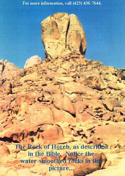
Locating Horeb
Can we now pinpoint the Mountain of YEHOVAH God -- the REAL Mt. Sinai -- with exactitude? We have seen all the EVIDENCE plainly pointing our gaze to the ancient and fabled land of Midian. Are there any clues that will lead us right to the very slopes of the mountain of the lawgiving? Keep reading, for there certainly are!
Returning to Peake's Commentary once again, we learn the following: "It [Mt. Sinai] is sometimes called HOREB (E, D), sometimes SINAI (J, P), the names appearing to be interchangeable. Some think that Horeb refers to the RANGE and Sinai to the PEAK; others the opposite. Heinisch holds that there is much to be said for the conjecture of Sandra (Moses und der Pentateuch (1924), 37, 359) that Horeb represents the MIDIANITE NAME for the mountain and Sinai the one used by the CANAANITES and the Amorite population of the peninsula. IT IS THUS CALLED HOREB HERE, SINCE MOSES IS AMONG THE MIDIANITES...." (p. 212).
This explanation is CLOSE, but not one-hundred percent correct! The British author and archaeologist H. St. John Philby spent a significant portion of his life exploring the wadis and mountains of northwest Arabia -- the biblical land of Midian. In the book he wrote following his exploration of Midian, Philby outlines his adventures in that mountainous land:
From here my guide and I climbed up the cliff to visit THE 'CIRCLES' OF JETHRO on the summit of Musalla ridge, from which we climbed down quite easily to our camp on the far side. [Alois] Musil tells us that he had to fetch a circuit of two kilometres to approach the ridge from the north; but the more direct approach presented no difficulty. A cairn marked the spot where JETHRO IS SUPPOSED TO HAVE PRAYED, and all round it are numerous circles, the significance of which is difficult to guess: presumably some stance marked out for the benefit of pilgrims visiting the scene of Jethro's argument with the Midianites. from here I had a magnificent view of the WHOLE OF THE MIDIAN MOUNTAIN RANGE: with LAUZ and its sister peaks in the northeast and Maqla' a very little north of east, with the valley of al-Numair separating the latter from the long low RIDGE OF ALL MARRA, extending from east to south-east, where the TWO PEAKS OF HURAB stood out in front of the great range of Zuhd, which runs down to a point not far from the sea to our southward...the spot that held my imagination was the smooth, double-headed, granite boss of HURAB (pronounced HRUB by 'Id), AN OBVIOUS CANDIDATE FOR IDENTIFICATION WITH THE MOUNT HOREB OF THE EXODUS, with the burning bush and the tablets of the Law: THE ONLY CANDIDATE FOR THE HONOUR WHICH CAN CLAIM TO HAVE PRESERVED THE NAME.
Philby goes on to explore the area --
So far as I am aware the existence of THIS HILL IN MIDIAN HAD NEVER BEEN NOTED BEFORE; and naturally I was anxious to explore it and its surroundings....A couple of miles brought us to the edge of a wide chasm, with forty-foot cliffs of sandstone and silt along the left bank, and an easier rise on our side, strewn liberally with large granite and basalt boulders from the steep flank of HURAB just ahead of us. The Land-Rover could go no farther, and I made my inspection of the VALLEY and the edge of the mountain on foot. The massif is granite, with dykes of basalt at intervals, running from south-west to north-east at an angle of thirty degrees. I did not attempt to emulate Moses' feat of climbing it, if indeed he did; but I made a CAREFUL SEARCH IN THE VALLEY and its sandstone cliffs in the hope of finding a few Badawin wasms, BUT THE CHANNEL ITSELF, 100 YARDS WIDE AND THICKLY COVERED WITH ACACIA BUSHES AND TREES, AND THE DEEP GORGE OF THE MOUNTAIN FROM WHICH IT EMERGES, WERE QUITE IMPRESSIVE....According to Hasballah, THE NAME OF HURAB APPLIES PRIMARILY TO THE WADI, while he called THE MOUNTAIN ITSELF AL MANIFA (which simply means 'the lofty'). -- The Land of Midian. Ernest Benn Ltd., London. 1957, pp. 222-224.
Philby was not the first to explore WADI HROB -- Alois Musil himself camped there during his exploration of Midian; and he specifically IDENTIFIED HROB WITH HOREB.
If you examine a detailed map of this area, the WADI HOREB can be seen to run into the foothills of one of the MOST IMPRESSIVE PEAKS OF MIDIAN, and also the HIGHEST -- JABEL EL LAWZ (LAUZ)!
Jabel el Lawz is indeed impressive. Those who have looked up at its massive granite slopes are awed by its sheer ruggedness and size. It continually impressed H. St. John Philby as he wandered through the mountains and wadis of Midian. "...I took advantage of our long halt to inspect the country from the top of a charming 100-foot hillock of rhyolite and andesite on the very edge of the Afal channel. It was a nice fine morning with a coldish breeze blowing from the north. The MAIN PEAK OF LAUZ, partly in cloud, rose to the south-east of our position....The upper part of the valley varied from 500 to 1,500 yards in width, with occasional wider basins allowing of splendid views of THE GREAT MOUNTAINS, INCLUDING THE LAUZ SUMMIT on which there seemed to be a patch of snow. the guide confirmed that it was snow: and, if so, it was the first and only time that I have ever seen snow in Sa'udi Arabia...."
Philby notes that Burton never explored the gullies of Lauz: "Burton had never examined the gullies of Lauz or the other mountains of the Midian chain; and it is not unlikely that they may contain minerals of various kinds. The basalt pyramid of Maqla' looked climbable, but THE SHEER GRANITE OF THE LAUZ PEAKS would have needed more time and energy than I had at my disposal. SO FAR AS I KNOW THEY [THE PEAKS OF LAUZ] HAVE NEVER BEEN CLIMBED BY ANY HUMAN BEING."
Philby punctuates his book with superlatives such as "the GREAT MASSIF of Jabal Lauz," "Lauz and the other GREAT GIANTS of Midian," "the GREAT PEAK of Lauz," and "the Lauz MASSIF." Is THIS peak that so impressed Philby and Musil the REAL Mt. Sinai of the Bible?
The Real Mt. Sinai Discovered?
In July 1988 a report came out in the High Flight Foundation Newsletter that startled its curious readers:
Great news! We strongly feel that the REAL Mt. Sinai has been discovered. Since February, we have been searching in Egypt and Saudi Arabia in an attempt to find the real Mt. Sinai, currently believed to be in Egypt. The Bible, however, is quite clear that Mt. Sinai is IN ARABIA (Galatians 4:25). We have found an UNDERWATER LAND BRIDGE IN THE RED SEA in the area of the tip of the Sinai peninsula. This land bridge was photographed and found to be a perfect underwater bridge to Arabia.
Larry Williams and I [Bob Cornuke] have taken two trips to SAUDI ARABIA and traveled to JABEL AL LAWZ. This mountain is believed by some Biblical scholars to possibly be the REAL Mt. Sinai. JABEL AL LAWZ is an 8,000 ft. mountain with a HUGE VALLEY at its base. In this VALLEY we found an ANCIENT ALTAR with petroglyphs of the Egyptian bullgod, Hathor, inscribed in the rocks. We feel this is the altar where Aaron made the Golden Calf. There were also very strong readings of the mineral gold registered at this site. -- Report by Bob Cornuke on Noah's Ark and Mt. Sinai.
In the book Treasures of the Lost Races, published in 1982, author Rene Noorbergen writes about the REASONS for identifying Jebel el Lauz with the Sinai of the Exodus:
The theory on which Ron Wyatt was basing his exploratory trip to the Middle East was founded on TWO VERY OBVIOUS POINTS made by Flavius Josephus and recorded in the Bible. Both mention that the Hebrew children went SOUTH FROM EGYPT, through the desert, ending at the shore of the Red Sea in an area where 'the mountains were closed with the sea.' That the Red Sea at that time EXTENDED, in name at least, AS FAR AS EILAT AT THE TOP OF THE GULF OF AQABA can be seen in I Kings 9:26, where it states that 'King Solomon made a navy of ships in EZION-GEBER, which is beside ELOTH, ON THE SHORE OF THE RED SEA, IN THE LAND OF EDOM.'
Wyatt reasoned therefore that the Israelites had crossed the Sinai from west to east and had finally reached an area on the EASTERN COAST (GULF OF AQABA) where a mountain range met the sea. According to the record, the Egyptians had taken over the mountain peaks near the area to prevent the Hebrews from escaping. It also mentions that AFTER they had crossed the Red Sea, Moses took them to 'Mt. Sinai in order to offer sacrifices to God.'
Rene Noorbergen discusses Wyatt's exploration of the eastern shore of the Sinai peninsula:
A careful examination of the EASTERN SHORE OF THE SINAI PENINSULA allows for only one place where two million people and their flocks can be gathered. it is the wide expanse of beach near NUWEBA, the south end of which is closed off by steep mountains! Nearby is a wide and wild mountain gorge known as the WADI WATIR, AN ANCIENT DRIED-OUT RIVERBED that forms a NATURAL ROADWAY into the Sinai desert. What's more, the TRADITIONAL MT. SINAI is deep within the SINAI DESERT, while both the Bible and Josephus indicate that Moses took the Hebrews to Mt. Sinai after they crossed the Red Sea into what is now known as ARABIA. Interestingly, not far from the opposite shore is a MOUNTAIN KNOWN AS JABEL EL LAWZ, A STEEP, FORBIDDING PEAK. Is it perhaps that this is the Mt. Sinai that Moses speaks of? There are many different theories regarding the possible location of the real Mt. Sinai, and Ron Wyatt's location wasn't all that farfetched.
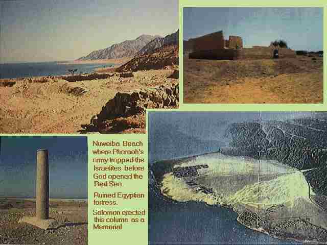
The Beach at Nuweiba
The route the Israelites took is related next --
He held that the Israelites, after leaving Egypt, went DOWN the western side of the Sinai along the Gulf of Suez and crossed the Sinai from west to east through its most rugged mountainous section by travelling over the dried-out riverbeds that run into each other. Their route, according to him, could well have gone via the Wadi Feiran, connecting with the Wadi El Akhdar, which in turn runs into the Wadi Salaqa, becomes the wadi Zaranek, and eventually meets the Gulf of Aqaba via the well-known Wadi Watir. The Wadi Watir is the only wadi that ends at a wide beach-like expanse whose southernmost end is cut off by steep mountains. An escaping horde of people arriving at the Red Sea via the Wadi Watir had ONLY TWO CHOICES: to be annihilated on the beach by the pursuing armies that could enclose it from the north, while it was hemmed in by mountains on the west and south; OR to go FORWARD INTO THE WATER. There simply could have been no other. -- Pp. 163-166.
Ronald E. Wyatt -- amateur archaeologist and theologian from Tennessee -- has long been interested in the location of Mt. Sinai. In 1978 he did some exploratory work in the Red Sea; and, in 1984, after spending 75 days in a Saudi Arabian jail, returned to the U.S. to be interviewed by the CBS MORNING NEWS on April 17. In the interview Mr. Wyatt explained the choice of Jabel El Lawz as the REAL Mt. Sinai:
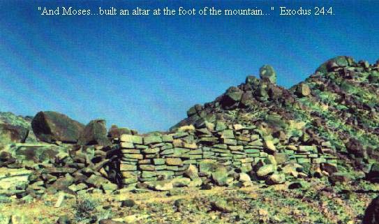
We found some chariot parts that looked like the chariots found in King Tut's tomb in the Gulf of Aqaba, WEST OF THIS JABEL EL LAWZ. Now, we found these at depths from 60 feet out to 200 feet and over a stretch of about a mile and a half. And we believe that was the crossing site, so in the Biblical narrative, they arrived at Mt. Sinai after crossing the Red Sea. The language in the Bible indicated that they stayed 'IN' A MOUNTAIN; ENCLOSED IN A MOUNTAIN. So, an aerial map showed that this JABEL EL LAWZ HAD A LARGE VALLEY ENCLOSED IN THE RIM OF AN ANCIENT VOLCANO. There's about 5,000 acres in there. We felt this was the place. And, in Exodus 24:4 and Leviticus 6:28, 11:33 and 15:12, it tells of SOME ARTIFACTS that were to be found. There would be TWELVE PILLARS OF STONE AND AN ALTAR AND SOME POTTERY, and so this is why we looked at that particular mountain.
In the following year (1985) David Fasold of Port Salerno, Florida accompanied Ron Wyatt to Jabel El Lawz to carry out an archaeological survey. Mr. Fasold relates the events of that fruitful expedition:
On April 2, 3 and 4 of 1985, an archaeological survey was conducted by Mr. Ronald Wyatt of Madison, Tennessee, at JABEL EL LAWZ, KINGDOM OF SAUDI ARABIA. The molecular survey, leading to points of interest, was carried out by Mr. David Fasold of Port Salerno, Florida, who accompanied Mr. Wyatt and Samran Al-Moteiri, a prominent citizen of Tabuk [town in NW Saudi Arabia], who had gained permission to conduct the survey. The purpose of the investigation was that Mr. Wyatt's premise that the mountain, JABEL EL LAWZ, REPRESENTED THE TRUE MT. SINAI IN THE LAND OF MIDIAN, which is, of course, IN NORTHERN ARABIA, and NOT in the Sinai Peninsula.
THE SITE IS LOCATED SOME 144 KILOMETERS BY ROAD FROM TABUK TOWARDS HAGL. When soon after crossing a bridge, a dry wadi is followed west for a distance of 48.7 kilometers.
Questioning a Bedouin tribesman proved very fruitful --
Upon questioning a Bedouin in the area if this was indeed Jabel El Lawz, Ibrahim Salem Frich responded with "nahm, Jabel Musa henna!", which means "YES, THE MOUNTAIN OF MOSES IS HERE!"
The Bedouin showed us the REMAINS OF A TEMPLE that, during the reign of Sulyimin, the Turkish " Sulyimin, the great," has been stripped of cut stone for building material for a mosque in Hagl. I would have liked to have seen this mosque to ascertain how many blocks were removed from the site, but time did not permit.
25 rectangular blocks, 16 1/2" by 8 1/4," varying in length from 26 1/4" to 39", were scattered at the site below a RAISED PLATFORM, and 10 pillar sections are visible, varying in height from 10" to 26" with a 22 3/4" diameter. The TEMPLE PLATFORM represents 1/4 of a circle leading from a set of three pools joined to a large rock best described as the size of an "up-ended" car, which carries slightly incised, esoteric symbols. This site nestles between TWO MOUNTAINS.
The molecular survey uncovered some interesting remains:
Closer to the wadi, the molecular survey uncovered a line of 12 CIRCLES OF STONE with an outside diameter of 18 feet, consisting of three rows of stones in thickness. It would appear to this writer that the construction was not a "shaft grave" or walls for wells, but the REMAINS OF STANDING TOWERS. THE 12 were spaced five feet apart from one another in a straight line bearing 193 degrees magnetic. the elevation at this site is 4,050 feet, some 20 feet above the wadi, 70 feet below the TEMPLE REMAINS and less than 1/8 of a mile distance from THE TEMPLE; from tower number four, JABEL EL LAWZ bearing 216 degrees and the other mountain at 270 degrees.
Directly across the wadi, a survey line was followed to a low grouping of stones that were COVERED WITH PETROGLYPHS in the following manner: an area of the stone was washed with a substance that was absorbed by the rock about 1/8 of an inch; a pointed tool was then employed that, when struck against the blackened rock to a depth of 1/4 of an inch, left a white mark. The artist thus portrayed images of Hathor and Apis, the Egyptian sacred cows, in dotted outline with their markings, in several cases, six figures apiece.
When shown to an archaeologist sent from Riyad University to verify the site, Wyatt was congratulated on the discovery and the area promptly closed. All photographs were confiscated.
Later visits by Larry Williams finds the area fenced off --
Two visits to the site in the spring of 1988 by Larry Williams, an explorer from Rancho Sante Fe, California, verified by photograph that the petroglyph site was now enclosed by a 12 foot, chain link fence and barbed wire, with a large blue and white 4 foot by 8 foot sign in the Arabic and English that it was a protected site of historical importance. Two other sites, the TEMPLE and the towers, are protected by the same type fence, encircling TWO entire mountains.
This writer feels that the cost involved in the fencing alone shows that the Saudis are taking this site very seriously....I can assure you that this was Wyatt's first trip to the site, but not his first attempt. I can personally verify that the discoveries were made in accordance with the theory formulated by Wyatt that the Exodus route from the Egyptians crossed the eastern arm of the Red Sea, INTO MIDIAN AND RETURNING TO MT. HOREB -- JABEL EL LAWZ. -- Discovered: Noah's Ark, by Ronald E. Wyatt. World Bible Society, Tennessee. 1989, pp. 45-47.
All the evidence we have covered CLEARLY points to the land of Midian on the eastern side of the Gulf of Aqaba as being the CORRECT LOCATION for Mt. Sinai -- the Mountain of YEHOVAH God.
Jebel el Lauz appears to be the REAL mountain of the lawgiving; and we wait with eager anticipation for further evidence to emerge from this site in Saudi Arabia and from the pen of Ronald Wyatt who made the startling disclosures we have just read about.
YEHOVAH God, in his good time, will reveal ALL TRUTH to those who serve and obey Him.
|
Hope of Israel Ministries -- Taking the Lead in the Search for Truth! |
|
Hope of Israel Ministries |
 |
Scan with your Smartphone for more information |