Hope of Israel Ministries (Ecclesia of YEHOVAH):
From the Mississippi to Mexico --
The Great Migration of the Aztecs!
When the Spaniards landed in Mexico in 1519, they discovered a civilization that took their breath away with its opulence and grandeur -- and also with its insatiable appetite for human sacrifice. The Catholic monks and friars that accompanied Cortez on his expedition began to probe and delve into the origins of the mighty Aztec empire -- recording the legends and traditions of the great migration that took the Aztecs to the valley of Mexico. Modern scholars, however, spurn these traditions and label them as myths and fables, thus ensuring that the truth of the origins of this enigmatic people will forever elude them. This article, examining the legends and traditions and historical facts surrounding the origins and ultimate rise to power of the Aztec people, takes the reader on an epic adventure down the pathways of history to the ancient land of Canaan. Here, regardless of what the scholars claim, is the ultimate origin of the Aztec people! Will you join us on this grand adventure? |
by John D. Keyser
Disembarking from their ship in March of 1519 at a point somewhere close to where modern-day Mexico City is located, Hernando Cortez and his mottley band of buccaneers and mercenaries discovered that the country was populated with a people who called themselves Aztecs. After subjugating the native town of Tabasco, Cortez learned from them the existence of the mighty Aztec empire and its ruler Montezuma II.
After taking numerous captives, the Spaniards sailed just north of San Juan and established a town there which they named La Villa Rica de la Vera Cruz -- now just Veracruz. Here Cortez organized an independent government and started negotiations with Montezuma, who tried to persuade Cortez not to enter the capital city of Tenochtitlan.
Ignoring the Aztec leader's wishes, Cortez marched inland towards the capital. The organized armies of the Aztecs, and their Emperor Montezuma, met the Spaniards not far from the coast, but decided not to oppose the Spanish invaders directly by force of arms. Montezuma decided to await their arrival at the Aztec capital and learn more about their purposes.
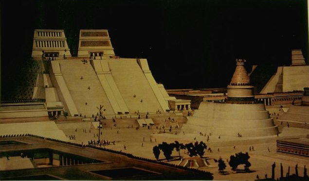
When the Spaniards arrived at the Aztec capital, they were overcome with amazement. Emerging from the mountain pass that leads to the Valley of Anahuac, they were greeted by a beautiful and unexpected sight: a broad, lush valley surrounded by snow-covered mountain peaks; and situated among several beautiful lakes could be seen glistening in the distance a magnificent metropolis -- the great Tenochtitlan!
In order to enter Montezuma's palace, Cortez and his men had to cross several inner courtyards with fountains shooting crystal-clear water into the air. Their hosts led them through great ante-chambers with ceilings panelled in beautifully carved aromatic woods. Incense-burners spread an all-pervasive scent pleasant to the smell. Above the main entrance to the palace the conquistadors found an effigy known to them from home -- an eagle with a panther in its talons.
In the Historia Verdadeira Da La Conquista Bernal Diaz, who accompanied Cortez on all his expeditions, wrote --
And we saw so many towns and villages on the surface of the water and many more still on the mainland, we were seized with wonder, and we said, it must be magic...for everywhere great towers, temples and pyramids rose out of the water; many a soldier thought he must be dreaming.
Even Cortez himself records in surprise:
You find houses like those kept up by apothecaries, where you can buy medicinal potions ready for drinking, ointments and plaster. You see barber's saloons where you can take a bath or have your hair cut. You come across houses where you can eat or drink against money.
It has been estimated that the city of Tenochtitlan had about 60,000 houses and 300,000 residents. The amazed Spaniards strode along wide streets with huge mansions built of a red porous stone -- nearly all having roof-gardens full of luxuriant plants. The streets were regularly swept clean and well-washed. Huge pipes carried fresh drinking water from the mountain of Chapultepec right into the middle of the city.
At the height of its prosperity, Tenochtitlan was a lively, teeming city with arsenals, granaries, an aviary, an enclosure for wild animals looked after by keepers (just like the zoos of today), numerous fountains and fish-ponds and large reservoirs set in chequered marble. There were homes for state visitors, schools, special blocks for priests' living quarters, and other large buildings. Looking across the city skyline, the Spaniards could see the tops of temple pyramids, the largest of which was situated in the satellite town of Cholula. This engineering marvel was half as tall as the Great Pyramid of Giza, but measured TWICE as long!
The City of Tenochtitlan
Bernal Diaz writes about the wonderful market-place at Tenochtitlan --
When we reached the square called Tlatelolco we stared in amazement. Not only at the mass of people and the profusion of goods, but also at the orderliness that reigned in everything, because we had never seen the like of it before.
Cortez was so struck by the market that he wrote: "There is...still another market, twice as large as Salamanca's [city in Spain] and entirely surrounded by arcades."
Cortez and his men could not say enough about this fantastic spectacle -- the tens of thousands who went there daily. The Aztec men wore cloaks slung over one shoulder and tied round their neck; their robes were adorned with fringes, tassels, wide belts and all kinds of jewellery. The women wore several skirts, one on top of another, with very ornate ribbons and beautiful embroideries. Many had their faces covered with thin veils made from aloe fibers or rabbit wool. All the women wore long plaits.
Everything that was found at home in the Spaniard's world was available in the market of Tenochtitlan.
There were special stalls for Cholula's jewelers and potters, for Azcapotzalco's goldsmiths, for Tezcoco's painters, for Tenayuca's stone-cutters, for Xilotepec's hunters, for Cuitlahuac's fishermen, Quauhtitlan's basket- and chair-weavers, and for Xochimilco's florists.
The variety of curios you could purchase were limitless. There were golden fish with scales of gold, golden birds with golden feathers and movable heads, vessels made from all kinds of wood -- varnished or even gilt, bronze axes, warriors' helmets with crests of animal heads, quilted cotton waistcoats for the warriors, feather armor, swords with obsidian blades, razors and mirrors from cut stone, hides and leather goods of all kinds, tame and wild animals.
In fact, it has been noted, delicate artistry reached such a high level in Aztec civilization that a life-size human skull was carved out of a solid piece of crystal. This famous piece of work is now found in the British Museum.
At the food-stalls mountains of poultry, fish and game were being offered, a luxuriant array of vegetables, maize, baker's wares, bread, cocoa and Pulque -- an intoxicating drink. On top of all this was a profusion of flowers, beyond anything the Spaniards had ever seen.
Wealth was so great in the Empire that even the common people were able to enjoy the prosperity that filled the city with all kinds of merchandise.
The merchants' activities centered on the great market at Tenochtitlan's satellite city, Tlatelolco, undoubtedly the greatest emporium in pre-Columbian America. Notes Brian M. Fagan: "Thousands of merchants and farmers displayed their wares in an open plaza that assaulted the visitor with bright sounds and peculiar smells. Dark-watered CANALS brought dozens of small canoes to the very heart of the marketplace" (Kingdoms of Gold, Kingdoms of Jade. Thames and Hudson, 1991, p. 36).
Bernal Diaz takes up the description of the Tlatelolco market-place --
Let us begin with the dealers in gold, silver, and precious stones, feathers, cloaks, and embroided goods, and male and female slaves who are also sold there...Next there were those who sold coarser cloth, and cotton goods and fabrics made of twisted thread, and there were chocolate merchants with their chocolate. In this way you could see every kind of merchandise to be found anywhere in New Spain...There were those who sold sisal cloth and ropes and the sandals they wear on their feet, which were made from the same plant. All three were kept in one part of the market, in the place assigned to them, and in another part were the skins of tigers and lions, otters, jackals, and deer, badgers, mountain cats, and other wild animals, some tanned and some untanned, and other classes of merchandise...
Bernal Diaz walked through the great market-place the day after Cortez and his band entered the Aztec capital in 1519. "We were astounded at the great number of people and the quantities of merchandise, and at the orderliness and good arrangements that prevailed," he wrote. "The murmur and hum of their voices and the words that they used could be heard more than a league off." Tenochtitlan's market was a hub and life-line of the Aztec world -- an emporium so vast that one Spanish chronicler estimated that 20,000 to 25,000 people visited it a day. On a scheduled market day as many as 50,000 attended.
There was, of course, a dark side to the Aztec civilization: human sacrifice was well established with them and formed a central position in their belief-system. Writes Graham Hancock --
It is recorded, for example, that Ahuitzotl, the eighth and most powerful emperor of the Aztec royal dynasty, 'celebrated the dedication of the temple of Huitzilopochtli in Tenochitlan by marshalling four lines of prisoners past teams of priests who worked four days to dispatch them. On this occasion as many as 80,000 were slain during a single ceremonial rite.' (Fingerprints of the Gods, NY: Crown Trade Paperbacks, 1995, p. 97).
As hideous as it sounds, the Aztecs liked to dress up in the flayed skins of sacrificial victims. Bernardino de Sahagun, a Spanish missionary, attended one such ceremony soon after the conquest:
The celebrants flayed and dismembered the captives; they then lubricated their own naked bodies with grease and slipped into the skin... Trailing blood and grease, the gruesomely clad men ran through the city, thus terrifying those they followed...The second-day's rite also included a cannibal feast for each warrior's family.
Spanish chronicler Diego de Duran was witness to one such mass sacrifice. In this instance the victims were so numerous that when the streams of blood running down the temple steps "reached bottom and cooled they formed fat clots, enough to terrify anyone" (Aztecs: Reign of Blood and Splendour, p. 103). By the beginning of the 16th century it has been estimated that the number of sacrificial victims in the Aztec empire as a whole had risen to the staggering number of around 250,000 a year!
A civilization of this nature was doomed from the beginning -- it was just a matter of time. The Spanish conquistadors only hastened the end of this cruel and barbarous people, like Joshua entering the Promised Land of Cannan. Within a few years the great city of Tenochtitlan and the Aztec empire lay in ruins.
The Mysterious Aztlan
Where did this energetic and powerful people come from? Were they indigenous to Mexico as modern scholars would have you believe, or did they migrate to the Valley of Mexico in the distant past? According to the Spanish historian Sahagun and other friars, the legends of the Aztecs place their origins on a mythical island in a lake named AZTLAN -- somewhere north of the Valley of Mexico. The legends tell how a group of at least seven Aztec clans migrated to the Valley of Mexico -- losing themselves in the "mountains, the woods, and the place of crags." They arrived, the legends say, in the late-twelfth century A.D. "The rock is called Chicomoztoc, which has holes on seven sides; and from there came forth the Mexicans, carrying their women...that was a fearsome place, for there abounded the countless wild beasts established in the area...and it is FULL OF THORNS, OF SWEET AGAVE, and of pastures; and being thus very far-off, no one still knew later where it was."
Can we know where it was?
In the Nahuatl language of the Aztecs the word Aztlan is made up of two words -- "aztatl" and "tlan(tli)," meaning "heron" and "place of," respectively. The Nahuatl language is often said to include three levels of meaning for its words or expressions: literal, syncretic and connotative. The connotative meaning of Aztlan, due to the plumage of herons, is "Place of Whiteness." The mythical description of Aztlan would have it to be an island.
In the origin myths of the Aztecs, they emerged originally from the bowels of the earth through seven caves (Chicomostoc) and settled in Aztlan, from which they subsequently undertook a migration southward in search of a sign that would indicate that they should settle once more. This myth coincides with the known history of the Aztecs as a barbarous horde that migrated into the central plateau of Mexico in approximately 1193 A.D. They founded their capital, Tenochtitlan, on an island on Lake Texcoco circa 1202 -- having subsisted in the area for most of the intervening years.
Funk & Wagnalls New Encyclopedia (Volume 3, page 68) states that "Aztlan, the Nahua word from which Aztec is derived, has been variously interpreted as 'heron place,' 'place of the heron clan,' 'white place,' and 'seacoast'; in Aztec legend it signifies the original home of the Aztec, an unidentified place to the north from which they had migrated, finally reaching the valley of Mexico in the 12th century."
According to The Facts On File Dictionary of Archaeology, "their [the Aztecs] origin is obscure, partly because of the deliberate destruction of their own records, but tradition holds that in 1193 A.D. the last of seven Chichimec tribes left Aztlan, a mythical birthplace somewhere north or west of Mexico, and filtered south" (edited by Ruth D. Whitehouse. NY: Facts On File Publications, 1983, p. 42).
In Chicano folklore, Aztlan is often appropriated as the name for that portion of Mexico that was taken over by the United States after the Mexican-American War of 1846, on the belief that this greater area represents the point of parting of the Aztec migrations. There is much truth to this in the sense that all of the groups that would subsequently become the various Nahuatl-speaking peoples of central Mexico passed through this region in an earlier time. This is proven by the existence of linguistically related groups of people distributed throughout the U.S. Pacific Intermontane region, the U.S. southwest and northern Mexico, known as the UTO-AZTECAN-TANOAN GROUP, which includes such tribes as the Paiute, the Shoshoni, the Hopi, the Pima, the Yaqui, the Tepehuan, the Rara'muri (Tarahumara), the Kiowas and the Mayos.
There are clues in the Aztec legends that indicate the southwestern United States was the Aztlan of their origins. The legends state that Aztlan "is full of thorns, of sweet agave" and of "countless wild beasts." A place of thorns and agave certainly indicates a desert region. This, coupled with the fact that there is a national park called the Aztec Ruins National Park in northern New Mexico, would tend to verify the Chicano concept.
The tribes that settled in the southwestern United States called themselves "Uto-Aztecas." The members of this branch of the linguistic family uto-Azteca are the tribes (mentioned above) in the United States, with branches in the Mexican states of Sonora, Chihuahua, Sinaloa and Durango in the central part and the Nahoas or Aztecs in the southern part of Mexico.
In all these areas the language used by these tribes is IDENTICAL. Colonel A.G. Brackett says (Report of the Smithsonian Institution, p. 329),
A person who speaks the Shoshone language can be understood by all the tribes, from Mexico to Rio Columbia, without difficulty.
The German linguist, Johann Karl E. Bushmann, after many years of research, concluded that the languages of these Indian tribes were all of THE SAME FAMILY. He published the results of his investigations in four volumes entitled Die Spuren der Aztekischen Sprache im Nordelichen Mexiko und Hoberen Amerikanischen Norde (Berlin, 1859). Many years after his original research, the Catholic missionaries established the fact that ALL of these people were of one language. This is further proof that the Aztecs, in the last leg of their migrations, came from the U.S. Southwest.
The Great Drought
States Dr. Benjamin Rea in his work The Roots of the American Indian --
The tribes furthest south in Mexico, the Aztecs, departed from a place in the north called Chicomoztoc, according to their own legends. We believe that they came from the region that is today Texas-Oklahoma-New Mexico, and it is from this region we come across a NETWORK OF CANALS that were used for irrigation. The employment of irrigation made possible the development of their agricultural system, which continued to be their means of support until some CATASTROPHIC EVENT forced them to migrate further south. What could have happened to make them undertake an exodus of that magnitude? A horrible invasion by enemy forces? An epidemic? Could a DROUGHT have forced this departure? -- Ehud, p. 67.
The traditions of the Wyandotte Indians indicate that a precursor to a great drought, a mighty storm from off the Pacific Ocean, ravaged the southwestern United States and the homeland of the Aztec ancestors --
It seems that many centuries ago the inhabitants of America, who constructed the towns and cities throughout the Mississippi Valley, had to flee TOWARD THE SOUTHWEST because a very powerful enemy army was approaching. Many centuries past, and one day an Indian messenger returned with alarming news from these exiled tribes. He related that a beast [a devastating storm] had disembarked on the coast and devastated everything that he found in his way. He destroyed with thunder and lightning. Nothing, it seemed, could stop his advance. -- Ibid., pp. 64-65.
The result of this devastating storm was famine -- to be followed by a long period of drought.
We can find incontrovertible proof that a great drought took place in the very region where these tribes existed -- a drought so severe that the region became a virtual desert. People that were always used to living near the water simply could not adjust to the arid conditions that prevailed.
The most acceptable date, and there are several, for the arrival of the tribes at Anahuac [Valley of Mexico] is 1193 A.D. in the last part of the twelfth century. Can we find any record of an extreme drought that occurred during these years?" Rea goes on to say, "Again, we can answer in the affirmative. This time, however, the record is not written in books, but in the tree-rings of those trees that were in existence at that time." (Ibid., p. 67.)
In 1956, in the United States, there occurred a drought of crises proportions. Government agencies in Texas searched through the ancient records left behind by the Spanish for any clues for a previous drought to equal the one in 1956. They even consulted the Indian legends and found, along with evidence supplied by tree-rings (the science of dendochronology) that there was -- and it occurred some six centuries earlier!
A Pasadena, California newspaper -- The Independent -- carried the following article on October 22, 1956:
Tucson, Arizona, October 22, 1956 (Associated Press) -- A scientist who has conducted a study of tree rings says that the present drought is the worst in over 750 years.
Dr. Edmund Schulman of the University of Arizona arrived at this conclusion after carefully examining thousands of trees that were selected with this purpose in mind...The trees produced a ring each year, explained Dr. Schulman. He commented further that broad rings are formed in years where there is an abundance of rain and narrow rings when there is a dry spell.
This occurred in Arizona -- an area that is normally arid.
If we take the time given by the Arizona scientist (750 years), we can calculate approximately when the Aztec ancestors began their march from the U.S. Southwest toward Tenochtitlan. If we take the drought of 1956 and subtract 750 from that date, we arrive at the year 1206 -- very close to the year given in works such as Aztecs of Mexico by G. C. Valliant and Stokvis' Manuel and the commonly accepted year of 1193 for the arrival of the Aztecs in Mexico.
The great migration of the Aztecs from Aztlan is recorded by Carlos Pereyra in his work Breve Historia de America that was taken from the Historia de las Indias de Nueva Espana by Diego Duran --
One day the priest, Coauhtloquetzqui, mindful of the information and warning from his god, realized that he had to inform his people of what he had seen and heard in his dreams. He ordered a convocation of all the people, the men and the women, the old men and women and even the children. And informing them about his dream and all that had taken place, he continued in this manner:
"You must know, my children, that this very night appeared unto me our god, Vitzilopochtli, and he told me that you should always remember what happened when we arrived at the hill named Chapoltepec, how Copil, his nephew was already there, having decided to make war against us, and how by his order and persuasion the nations surrounded us, and they killed our captain and leader and our god and king Vitziliuitli, driving us out of that place; who also gave the order for us to kill him, and we should take his heart, putting it in the place that he told us, I myself threw it among the reeds where it finally came to rest on a rock, and according to the revelation that this very night he gave me, he says from this heart has been born a cactus in the heart of this stone, so pretty and copious that a beautiful eagle makes its nest therein.
"This is the place that he tells us to search for, and, once we find it, we shall have great good fortune because this is the place where we will settle and become a great people....He tells us to name this place TENOCHTITLAN, in order to identify the city that is to become the queen and goddess and rule over all the land, and where we will receive all other rulers and where they will have to come to pay their respects to our supreme greatness."
Having heard the words of Cauhtloquetzqui, they humbled themselves before their gods and gave thanks to god..., they went out in search of the prophesied eagle and, after wandering from one place to another, they finally found the cactus and on top of it the eagle with wings extended toward the rays of the sun, taking in the heat of the sun and the freshness of the morning, and in its claws was a gallant bird with handsome radiant feathers.
After a arduous journey from the dry lands of the Southwest, these tribes arrived at their final destination. This is the very place the Spanish conquistadors met them several centuries later.
The Red Record
We have traced the Aztecs back to the southwestern United States -- where did they come from before that? To trace the origins of the Aztec people all the way back, we must turn to the pictographs of the Wallam Olum, known as The Red Record. The Red Record is the epic story of the Lenni Lenape Indians -- otherwise known as the Delaware. Within this record the Lenni Lenape's journey across the North American continent from the frozen wastes of Siberia (and beyond -- see our article, The Story of the Algonquian Indians) is found -- a journey spanning almost 100 generations. It is the oldest written account of a native North American people.
The Red Record (Wallum Olam)
The Indian source of The Red Record, the Lenni Lenape, or "Original People," were widely known and respected among the Indian tribes. With a deep knowledge of their past and a tradition of pictographic records, the Lenni Lenape were uniquely qualified to write this chronicle of ancient heroes and events.
Anthropologist Werner Muller writes --
In the long chain of tribes along the East Coast, one ethnic group stands out, not only in the European written sources but also in the judgment of the Indians themselves. This remarkable group was the Delaware, called in their own language the Lenni Lenape. They had a special status in the eyes of many other Indian peoples: they were reverenced as the "grandfathers," representatives, after a fashion, of authority and legality. -- Pre-Columbian American Religions, p. 162.
The Wallam Olum -- The Red Record -- is the Delaware's record of their ancient history, told in the form of an epic song. "Recorded in pictures and words, the saga tells of the rise to glory of the Lenni Lenape and their great Lenape family, also called the Algonquians, the most populous and widespread Native American language group in ancient North America" (The Red Record, translated and annotated by David McCutchen. Garder City, NY: Avery Publishing Group, Inc. 1993, p. 4).
The Red Record opens with the Lenape accounts of Creation and of the great flood of Noah's day. It then proceeds to the crossing of the Lenape people from Asia into North America, and of their encounters with the people who were already living there. It then goes on to recount the epic journey of the Lenape south and eastwards across the country, and the succession of chiefs who led them. Along the way, the Lenape people survive divisions, droughts and wars to finally end up in the beautiful Delaware River Valley. The Red Record ends with a description of the arrival of European ships on the Delaware River around 1620.
The description in The Red Record of the Lenape crossing the Bering Strait into America never indicates that they were the first or only ones to do so -- The Red Record clearly shows that when the Lenape crossed into America it was already inhabited; and many comments are made about the other tribes that they encounter on their journey across the continent. One such tribe is CENTRAL to the origin of the Aztecs.
As the Lenape migration neared the Mississippi River, they came upon agricultural lands where permanent settlements became possible. The Lenape soon discovered that farther to the east were the powerful people called the TALEGAS -- best translated as "foreigner" or "stranger." The origin of the Talegas is still unclear to the anthropologists and historians. The encounter between the migrating Lenape and the powerful Talegas is described by David McCutchen --
According to Heckewelder [an early missionary], the Lenape arrived at the Mississippi and followed it downstream to where it meets the Missouri River. This is the location of CAHOKIA, the most likely site for the "Talega king" in IV:52 [of The Red Record]. The great walled city of Cahokia, near where east St. Louis is today, was a commercial, political, and religious center of the last and most spectacular era of Moundbuilder culture -- the Mississippian Temple Mound phase. Cahokia has been described as "a cross between New York, Washington, D.C., and the Vatican." -- The Red Record: The Wallum Olam, p. 107.
The Pyramids of Cahokia
Almost no one has heard of the ruins of the great City of Cahokia -- the mounds, temples and canals that were constructed by the inhabitants of these cities or towns. But the explorers that saw these lands for the first time described in their records this astonishing discovery of mounds, forts and abandoned cities.
Why did the original inhabitants abandon them? Where did they go?
Unfortunately, almost all of the remains of this great civilization have disappeared beneath the dust of time, except for the great work accomplished by the American Antiquarian Society which was able to gather together the facts and data about this great civilization located in the very heartland of North America.
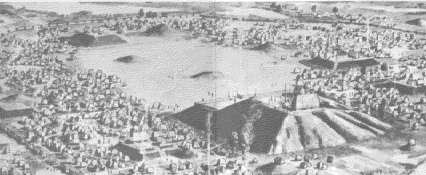
A View of Cahokia
One of the members of this organization -- United States archaeologist H.M. Brackenridge -- described the ruins in his own words. He examined the great pyramid of Cahokia in 1811-12, and we quote his fascinating record taken from A. J. Conant's Footprints of Vanished Races (pp. 56-58) --
In order for us to form a correct idea of these mounds and pyramids, it will be necessary to give the reader a general idea of the terrain in which they are located. This great American plain consists of extensive aluvial terrain that extends from the tributaries of the Mississippi River, from Kaskaskia to the Chakol River, some 190 miles in length and about seven miles in width; several rivers wind their way through the area; the earth of this region is extremely fertile and is not harmed by the constant overflowing of the mighty Mississippi. Many LAKES are scattered about through this area, which abound in fishes, and in the autumn of the year arrive many wild birds.
This valley is capable of supporting a population greater than any other part of the entire Mississippi Valley. The branches of the great river offer proof that this area once supported an ENORMOUS POPULATION. If, for example, the modern city of Philadelphia were to be abandoned, the traces of human existence would not be more numerous!
The author goes on to say --
The immense number of mounds and the quantity of human bones found everywhere on the surface gives ample evidence that this valley was once filled with towns and peoples. Almost all the land seems to be a superb resting place for its original inhabitants. Most outstanding of all are THE PYRAMIDS AND THEIR MOUNDS. A group of them is located about 12 miles to the north of Cahokia and another is located about 12 miles to the south of the river. There are MORE THAN 150 PYRAMIDS of various sizes. The western branch of the Mississippi also contains A CONSIDERABLE NUMBER.
A more detailed description of the pyramids to the north of the Cahokia River, which I visited in 1811, will give you a good idea of them all. I crossed the Mississippi coming from St. Louis and passed through a forest that ran along the edge of the river and entered a plain. After 15 minutes I found myself in the midst of some mounds. From the distance they looked like hay-stacks standing up in a meadow. One of the largest, which I climbed, had a base of 200 feet in circumference. The form of this mound was almost square, although there was evidence of the erosion caused by wind and water over the centuries. The level top had enough room to contain seven hundred men in a standing position. The view from this pyramid was beautiful beyond belief. You could see a plain with some wooded groves and some isolated trees: to the right the prairie extended to the horizon, to the left I could see the Cahokia River winding its way to the Mississippi. Within my view I was able to count FIFTY-FIVE PYRAMIDS and numerous mounds of various sizes. These all formed a semicircle.
I continued walking along the branch of the Cahokia and passed by EIGHT MORE PYRAMIDS within the distance of four miles before arriving at a larger connecting tributary. When I arrived at the base of the MAIN PYRAMID, I was astonished! I thought I must be viewing the great pyramid of Egypt. It was truly wonderful to behold! The construction of this one must have required the labor of thousands of men and many years of continuous labor!
Most people don't realize that the main pyramid of Cahokia had a surface area at the base GREATER THAN ANY OF THE PYRAMIDS IN EGYPT!! Although the pyramid of the sun near San Juan de Teotihuacan in Mexico is considered to be larger than the great pyramid of Egypt, the pyramid of Cahokia was MUCH LARGER than the one in Mexico. If you make a comparison, you can see that the pyramid of Cahokia was, without a doubt, THE LARGEST PYRAMID IN THE WORLD -- bar none! Here are the dimensions of the three greatest pyramids:
CAHOKIA ---------------------------- 1003 feet (Length of Side)
MEXICO ------------------------------ 752 feet (Length of Side)
EGYPT -------------------------------- 733 feet (Length of Side)
Exclaims Dr. Benjamin Rea --
Cahokia was the site of the LARGEST CONCENTRATION of pyramids, religious edifices IN ALL THE WORLD. What a city! What magnificent splendor! We can imagine ourselves transported to the center of a religious ceremony like the one described by A. J. Conant, a member of the Academy of Science of St. Louis, Missouri, which is quoted below:
Atop the mounds constantly burned the flames that were only extinguished at the end of the old year and were relighted by the rays of the sun when the priests focused the rays of the newly born Sun on the wood of the sacrificial fires. This took place amidst the most extraordinary solemnity. -- The Roots of the American Indian, p. 59.
According to early reports the fires were extinguished during the winter solstice when the days became shortest and the sun reached the lowest point in the southern sky, and the weather became very cold. "Then, to give life to the dying sun, the rays of the king of the heavens were focused on the altar of the sacrifices in order that, with the light of the fire that burned, he could see his way back to the north" (ibid., p. 53). This is the EXACT same ceremony that was celebrated in ancient Rome, Egypt and Babylon!
Conant continues with his account --
When the sacred flames were extinguished at the end of the year, fear and trembling filled all the land because the fires in all the houses throughout the land had to be extinguished also. Then the population waited in a state of horrified suspense, hoping for the dawning of a new day. Possibly the sun, angered by the believers, might remain in hiding behind the clouds. Meanwhile, the faithful thought about their past sins and, because of their enormous transgressions, expressed their fears and remorse in tears; but when the hour of first light arrived, everyone looked toward the Sacred Mound where the altars were still in darkness. At last, the eastern sky began to paint itself a glowing golden color -- it was the sign that their god was about to reappear and while they looked at the sun in all its splendor it grew brighter and threw forth its burning rays to the altar where the priests were waiting to concentrate the rays of the sun on the ritual firewood, as yet unlit. The people did not wait in vain because almost immediately the smoke began to rise from the altars and flames immediately became visible. Then the crowd broke out in joyful shouts and songs of happiness. This is how the new year was greeted. Messengers were given flaming faggots from the hands of the priests, and they distributed them among the faithful who, with wild exultation, carried the gift to their respective dwellings. In this manner they celebrated the festival of the sun.
As I mentioned earlier, Cahokia was the Vatican City of the entire Mississippi Valley. The people who constructed the mounds and the pyramids all paid homage to the same gods because they were of one blood and language. Foremost among their gods was the PLUMED SERPENT called Piasa. This enigmatic people built mounds throughout the length of the valley; and each tribal group or scattered settlement had an altar dominating their city. Today, the remains of this vibrant civilization can be found in the Ohio River Valley and in the states of Alabama, Mississippi, Louisiana and Missouri.

Home Construction in Cahokia
In all the areas where the mounds and pyramids are located, there were NATURAL AND ARTIFICIAL LAKES. It is interesting to note that the Aztecs ALSO chose to dwell near lakes. Right on the shores of these lakes in the Mississippi Valley the natives constructed their vast cities. "The cities were circular in shape and surrounded by walls. Behind the wall they carved out a large CANAL to enable the waters of the lake or river to enter. These canals provided them with an inexhaustible supply of fresh water and, in addition, made it possible for them to maintain a year-round supply of live fish" (ibid., p. 54).
The canals also provided transportation.
This type of city is found mainly in the counties of southeast Missouri. Even today, near the city of New Madrid, one can find ruins of a city that extended over an area of several square miles -- all enclosed within a wall! The remains of numerous mounds and dwelling-places remain to this day.
The people who lived in this and other cities of the region constructed the mounds, the pyramids, the walls and the canals. This kind of construction served two main purposes: it drained swampy areas and made possible the irrigation of dry areas. The egineers who designed and built the great pyramids of the Mississippi Valley would have little trouble designing and constructing the network of canals. Conant, in his previously quoted work, points out --
The prehistoric people of Missouri not only had developed a great urban civilization based upon an agrarian economy but also constructed giant edifices of earth and stone. This same race was also capable of constructing the ingenious system of interlocking canals. With amazing skill, the engineers developed an internal system of navigation, linking the lakes and rivers with the various metropolitan centers of the region, and it was by means of these interconnecting waterways that the cities received the needed produce. The Mississippi River served as the principal transportation artery. Dr. G.C. Swallow, in referring to one of these canals, said, "One of them, that I examined, measured 53 feet wide and was 14 feet deep." For a more adequate description of this type of construction, the reader is referred to Mr. George W. Carleton of Gayoso, Missouri, who wrote the following:
"In addition to our mounds, we can be proud of these ancient canals. Col. Juan H. Walker informed me that before the earthquakes [1812?], these canals -- we would call them little canals today -- clearly demonstrated their artificial origin. Since the area has again been inhabited, the land stripped of trees, and the ground cleared, we are able to see what the first inhabitants of the region constructed. One of the canals lies to the east of the little town of Gayoso. It now connects Great Lake with the Mississippi River. Beyond is the Pemiscot Canal. This canal unites the waters from Lake Pemiscot with Grand Lake. Another watercourse, or artificial canal, is known today as the Cypress Bend Canal. Col. Walker said that it was built to connect the waters of Cushion Lake with a canal that flows into Grand Lake. Lake Cushion is located to the north of Pemiscot County. By means of this network of canals, lakes and interconnecting canals, the inhabitants of this region possessed an interior navigation system from the Mississippi River to Gayoso via Great Lake and Lake Cushion and another canal to Lake Collins; from there, by means of other connecting canals, it continued to the east where it flowed into the Mississippi River, about six miles downriver from New Madrid." -- Pp. 77-78.
Many archaeologists and investigators say that the artificial rivers in the southern part of the United States are a gift handed down by the pre-Columbian Indians of this region!
The early explorers who came upon these ancient cities with their mounds and intricate system of interlocking canals were astounded by their unexpected discovery, and they raised two very important questions -- WHY did the inhabitants abandon these great cities? and WHERE did they go?
What makes the Mound-builder phenomenon so unique to archaeologists is the fact that there is NO SINGLE EVENT in terms of climate change that could have prompted such a mass exodus from a well entrenched way of life. Their art, agriculture, housing, forms of government, religion -- the whole shebang -- just disappeared!
The Great Confrontation
To answer these questions we must now return to the Wallam Olum -- The Red Record of the Algonquian-speaking Indians. According to this account -- which is widely accepted as referring to the HOPEWELL civilization -- the Lenape (Delaware) Indians remembered encountering these Mound-builders during their own eastward trek from beyond the Mississippi River. An 18th-century missionary among the Lenape wrote --
[The Lenape] discovered that the country east of the Mississippi was inhabited by a very powerful nation who had many large towns built on the great rivers flowing through their land. Those people (as I was told) called themselves TALLIGEW or TALLEGWI....Many wonderful things are told of this famous people. They are said to have been remarkably tall and stout, and there is a tradition that there were GIANTS AMONG THEM, people of a much larger size than the tallest of the Lenape. It is related that they had built to themselves regular fortifications or entrenchments, from whence they would sally out... (Moundbuilders of Ancient America, by Robert Silverberg. Greenwich, CT: N.Y. Graphics Society, 1968, p. 54f).
According to Professor Barry Fell, the Hopewellians seem to have been "mainly LIBYANS" of BERBER (Canaanite) stock, with, he suggests, SOME NEGROID ADMIXTURE (America B.C. N.Y.: N.Y. Times Book Company, 1976, p. 189).
So the Hopewell Indians called themselves TALLEGWI. This is, of course, the same ancient TELL or TALO root which is found in Finnish TALOSSA, the TALAYOTIC culture of the Balearic Islands in the Mediterranean off the east coast of Spain, and the BEAKER (Canaanite/Pictish) cultures of Toulouse, France. (See our article, Unraveling the Origins of the Mysterious Olmec!). Notes R. Ben Madison: "If any more proof were needed, it is this: The same Lenape legend refers to these Talossans both as Tallegwi and as Alligewi, with or without the initial T. This is a fundamental Berber phenomenon: in Morroccan Berber, for example, the name of the ethnic group is Amazigh, while the name of the language is Tamazight. The T functions as an article or gender marker. The SAME grammatical feature appears to be at work among the Hopewell: ALLIGEWI = Amazigh; TALLEGWI = Tamazight. This alternation, with and without the initial T, only makes sense in one human language, and that is Berber" (The Berber Project. Second (Revised) Edition. 1997, p. 19).
When the migrating Lenni Lenape reached the Mississippi River, they "sent a message to the Talegas, requesting permission to settle in their neighborhood as friends and allies."
The Red Record goes on to describe what happened next:
The Talega king denied this request, but promised to permit the Lenape to pass through his lands to find homes farther east. Peacefully, the Lenape began to cross the Mississippi. But when the Talega King saw how numerous the Lenape were, he became frightened, and ordered his warriors to attack. Talega war canoes swept across the river as armored Talega regiments massacred the Lenape who had already crossed. Enraged by this treachery, the Lenape vowed to "Conquer or die!" and joined with their Iroquois allies in an epic war of vengeance. Led by Sharp One (IV:55), the Lenape forces stormed across the Mississippi, defeating the Talegas, and besieging and capturing many of the Talega towns. -- Pp. 107-108.
The Red Record goes on to say:
After a long and difficult struggle, Talega resistance was crushed (V:57-59). The Red Record shows that four sachems [chiefs] came and went before the final victory (V:55-59). The war between the Lenape-Iroquois allies and the Talega must have been fierce, with the final sieges of the Talega Wars among the largest battles ever fought in ancient America. Formidable earthworks from this period can be found throughout the Ohio Valley. One such stronghold, Fort Ancient, had palisaded walls 13 feet high and 5 miles long, and could hold up to 10,000 people. -- P. 111.
The Flight Down the Mississippi
The Hopewell "interaction sphere" (to use archaeological parlance) decayed and fell apart around 400 A.D. As we have seen, both Iroquois and Algonquian Indian legends tell of wars against the Mound-builders -- whom they called "the Snakes" (Hyde, 54ff). It is on record that an elderly Indian informant in the mid-19th century recalled that the "First Dispersion" of his people -- the Mound-builders -- began in the eastern United States, near the Alleghany mountains of Pennsylvania ("Oral Literature and Archaeology," by Robert J. Salzer. The Wisconsin Archaeologist (1993). P. 101); this refers to the breakup of the Hopewell "interaction sphere." The Lenni Lenape also recalled (in The Red Record) in the late 18th century that "many hundreds of years ago" their ancestors indeed went to war with the Mound-builders in what is now Michigan, which would have to be Hopewell country. Missionary John Heckwelder recounted this bit of Lenape oral history in 1819 -- which describes the breakup of the Hopewell "interaction sphere":
Having thus united their forces the Lenape and Mengwe [Iroquois] declared war against the Alligewi [Tallegwi], and great battles were fought in which many warriors fell on both sides....No quarter was given, so that the Alligewi at last, finding that their destruction was inevitable if they persisted in their obstinacy, abandoned the country to the conquerors and fled down the Mississippi River, from whence they never returned. -- Mound Builders of Ancient America, 54f).
This is, without doubt, an accurate account of wars against the Hopewell by the Algonquians and Iroquois -- both of whom were invading the American Midwest at this time. Especially interesting is the fact that the Hopewell fled south, down the Mississippi River, and never returned. Also, they fled to the far Southwest.
Records The Red Record --
The defeated remnants of the Talega fled southward, never to return (V:59). The Natchez were among the descendants of the Talega who fled down the Mississippi River. Natchez legends told of a time when the people had lived far up the Mississippi to the north and east. -- P. 111.
"Anthropologists agree that a last glimpse of the Talega way of life, known as the MISSISSIPPIAN CULTURE, was preserved by the Natchez of Mississippi. The Natchez had an absolute king, known as the Great Sun, who ruled over a society of rigid classes: the Lesser Suns, the Nobles, the Honored Men, and, at the bottom, the peasants and laborers known as the Stinkers. They built great earthworks and pyramids as bases for their temples. Their pursuit of status and power sometimes led them to commit human sacrifices.
"They were probably the most absolutist tribal society known NORTH OF MEXICO." -- P. 108.
Historians date the birth of the Mississippian Culture to around 700 A.D. It was big and important and was the SAME "Mound-builder" culture as that in the upper Mississippi Valley. Notes R. Ben Madison, "the Mississippian culture was a Native American blending of Berber and MESOAMERICAN (AZTEC) influences. It was obsessed with death, and its artwork revels in skulls, bones, weeping eyes and other symbols of doom; it has come to be known among anthropologists as the 'Southern Cult,' the 'Death Cult,' or the 'Buzzard Cult.'" (The Berber Project, p. 25).
According to one Native American tradition, the Buzzard Cult was known among the Indians as the "Black Tortoise" (Salzer, p. 101). As we have seen, it featured a rigid caste system of priests and nobles ruling over commoners (who were referred to as "stinkers" or "stinkards"). This people built immense mounds that were used as platforms for their temples -- JUST LIKE THE MEXICAN PYRAMIDS (Carl Waldman, Atlas of the North American Indian, NY: Facts on File Publications, 1985, p. 21f). "In its heyday," notes Robert J. Salzer, "prior to about 1250 A.D., the Black Tortoise civilization was an immense centralized 'empire,' which overgrew the capacity of preliterate man to administer it. Like the Roman Empire, it had to be broken up into 'petty monarchies' which were easier to govern" ("Oral Literature and Archaeology," The Wisconsin Archaeologist, 1993, p. 101ff).
These Buzzard Cult peoples -- which included the Natchez and the Muskogians -- dominated much of the southeastern United States and survived into the 18th century in tiny pockets in the South.
If the original Adena-Hopewell mound-building culture in fact spawned the Buzzard people who spoke unrelated American Indian languages, then we should expect to find some language influence on the Natchez and Muskogian languages spoken by the Buzzard people. And this, not surpisingly, is EXACTLY what we find. There are clear lexical links between the Berber spoken by the mound-building culture and that spoken by the Buzzard people AND the Hokan languages of the Southwest.
The Flight To the Southwest
The Talega left their homes and cities taking with them few material possessions. Although we can follow their footprints to their final destinations, some of path has been obscured and, at times, we will call upon legends and folklore to clear up the missing steps. The traditions of the Wyandotte Indians supply us with this information:
It seems that many centuries ago the inhabitants of America, who constructed the towns and cities throughout the Mississippi Valley, had to flee TOWARD THE SOUTHWEST because a very powerful enemy army [the Lenape and Iroquois] was approaching. Many centuries past, and one day an Indian messenger returned with alarming news from these exiled tribes. He related that a beast had disembarked on the coast and devastated everything that he found in his way. He destroyed with thunder and lightning. Nothing, it seems, could stop his advance. -- The Roots of the American Indian, pp. 64-65.
Does this indicate that the natives who fled from Cahokia and other great cities of the Mississippi Valley were the same people who colonized Anahuac (the valley of Mexico City)?
The similarities between the inhabitants of Cahokia and Anahuac are striking. The dwellers in Cahokia built pyramids, canals, mounds, artificial lakes, etc. The same can be said for the inhabitants of Anahuac. Both civilizations cultivated corn and also, according to some authorities, wheat. In both civilizations tobacco was used. The religious system was IDENTICAL. We could go on and on with the similarities -- but let's get on with the story!
As we have seen, the civilization that occupied the Mississippi Valley had achieved a cultural level that anthropologists would classify as advanced. They had to flee from their homes when the Lenape-Iroquois allies attacked their cities. According to the Wyandotte Indians they journeyed to the Southwest and, according to The Red Record, also down the Mississippi to the Gulf areas.
If we draw a line from St. Louis to the Southwest, we arrive at the region that is presently known as Texas, New Mexico, Colorado and Oklahoma. There they established their cities, homes and villages.
Relates Dr. Benjamin Rea --
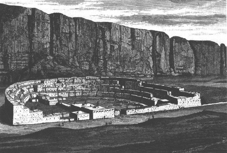
The ruins of the cities that they constructed in the basin of the rivers Bravo del Norte, Gila, and in the plains of the western United States still exist. Other branches of this family migrated to California and the southwestern United States. In this region they constructed beautiful cities such as Pueblo Bonito. Carlos Pareyra gives the following description (Breve Historia de America, p. 78-79) --
"Pueblo Bonito is in the form of a semicircular row of balconies carved out by pick on the sides of the Canyon del Chaco, New Mexico. It measures approximately 537 feet on its face and 309 feet deep at its deepest part and contains some 650 compartment-like dwellings." -- The Roots of the American Indian.
The Anasazi town of Pueblo Bonito was a Southwest phenomenon. It is a dramatic place set in a stark landscape. The huge canyon cliffs glow yellow in the sun, contrasting with the softer tones of desert sand, sage and occasional cottonwood trees. As the evening sun sets in Chaco Canyon, giant shadows are cast across the grandiose landscape which dwarfs the walls of the great pueblos that are camouflaged so naturally beneath the high cliffs. If you were to go back a thousand years flickering fires, barking dogs and the echoing murmur of Indian voices would have greeted the evening visitor. Today, all is quiet in this ancient land, and the timeless settlements of the Anasazi are an integral part of the arid landscape.
Writes Brian M. Fagan --
Chaco is an archaeologist's paradise. The 32 square miles of the canyon contain not only 13 "towns" and great kivas (ceremonial rooms), but more than 2,400 other archaeological sites of all kinds. It seems that this has always been a special place, visited by hunters and farmers for more than 8,000[?] years. The earliest pueblos, BUILT BETWEEN A.D. 700 AND 900 form small arcs, so laid out that each room was equidistant from a central pithouse. This pithouse soon became a sunken kiva, the focal point of ceremonial life in every Chaco settlement. -- Kingdoms of Gold, Kingdoms of Jade, pp. 204-205.
Archaeologists have realized that more often than not kiva architecture reflects an INTIMATE KNOWLEDGE OF THE SUN AND THE STARS. The great kiva at Casa Rinconada in Chaco Canyon, which dates back to the 11th century, has a main doorway that faces celestial north. "This is the fixed point in the nighttime sky round which all stars seem to revolve. Four huge wooden pillars once defined the cardinal directions, symbolizing the four trees that Earth people once climbed to reach their homeland" (ibid., p. 205). At solstice sunrise the rays of the sun enter to the right of the doorway and shine into a niche in the northeast wall -- marking the northernmost journey of the sun.
The semi-circular plaza was surrounded by more than 800 rooms at the town's peak, all within easy reach of the sacred kivas that were the heart of the settlement. During the 11th century at least nine major Chacoan "Great Houses" were erected -- each a massive undertaking. Archaeologist Stephen Lekson of the National Park Service estimates that each room required 40 beams, each from a separate pine or fir tree growing in a forest nearly 40 miles away -- to say nothing of tons of stone and clay!
Ruins in Chaco Canyon
In the early 1900s something quite fascinating was discovered. Some of the pioneer archaeologists who excavated at Pueblo Bonito noticed what appeared to be the remains of tracks converging on Chaco Canyon from the outside. "It is only in the past twenty years," writes Brian Fagan, "that AERIAL PHOTOGRAPHS and SATELLITE IMAGERY have revealed the full extent of the web of more than 400 miles of unpaved PREHISTORIC ROADWAYS that link Chaco to over thirty outlying settlements. The Chacoans had no wheeled carts or draft animals, yet they constructed wide roads across the desert, shallow tracks up to 40 ft wide, cut a few inches into the soil, sometimes marked by shallow banks or even low stone walls. The highways run straight for many miles, some of them 40 to 60 miles long, connecting as many as half-a-dozen settlements to one another and to Chaco" (ibid., p. 206). In its own way, the Chaco road system is as imposing as that of the South American Incas -- built three centuries later. Inca roads held together an empire. What, ask the archaeologists, was the purpose of the Chacoan roads?
It is apparent that the people of the Chaco settlements were major traders in turquoise, and imported large quantities of the stone from sources near Sante Fe, New Mexico -- about 100 miles to the east. They controlled both sources and exchange of the material over a wide area of the Southwest. Turquoise workshops and ritual ornaments in all stages of manufacture have been found in many small Chaco villages. Using the Chacoan road-system, thousands of people would have converged on Pueblo Bonito and the other large pueblos at times of important festivals -- bringing loads of turquoise ornaments, baskets of corn, nets full of painted clay pottery, and other goods for barter. Chaco was the hub of the Anasazi world.
Adds Brian M. Fagan --
What archaeologists call the CHACO PHENOMENON encompassed an area of more than 25,000 square miles of the San Juan Basin and beyond from the Rockies in the north to the Mogollon Mountains in the south, and from the turquoise mines near Sante Fe in the east to the Little Colorado River in the west....By A.D. 1115, at least seventy communities dispersed over much of northwest New Mexico and parts of southern Colorado were linked through the social, economic, and ritual network centered on Chaco Canyon. Judging from other such networks, trade and ritual activities were in the hands of a small number, not of noble lords, but of important kin leaders. -- Kingdoms of Gold, Kingdoms of Jade, pp. 206-207.
What is so remarkable about the Chaco experience is that this people flourished so well in such an unpredictable and hostile environment. "Despite many good rain years, there must have been periodic food shortages. And at least 20,000 pine beams went into the major pueblos, which must have decimated forests over a wide area, to say nothing of the firewood needed not only for cooking and heating, but for firing pots" (ibid., p. 207). As a result the Chaco communities overextended themselves in the bounty years of high rainfall and rendered themselves unusually vulnerable to the inevitable drought cycle that affected the San Juan Basin in the 12th century. Stretched to the limits, the Chaco system collapsed and the people moved away from the densely populated pueblos in search of a new home.
In the State of Arizona we can find literally hundreds of towns that were built in these rocky canyons. Even today these structures of stone and adobe give testimony about the level of cultural development attained by these inhabitants. The most well-known of these towns is Casa Grandes, located in the San Miguel River Valley in Chihuahua, Mexico -- where hundreds of these huts can still be found. They are also located in the Gila River basin in Arizona.
The Gila River flows from the eastern mountains of the Southwest into the mighty Colorado River -- through a mesquite-studded desert landscape. The summers are intensely hot in this semi-arid country, but the banks of the Gila were a veritable oasis, with fertile soil and abundant wildlife. In this area University of Arizona archaeologist Emil Haury excavated the undulating MOUNDS known as Snaketown -- so-called after the Pima Indian name of Skoaquik: "Place of Snakes." This is extremely important because the snake was central to the ritual and artistic functions of the Mound-builders of the Mississippi Valley, and was also the name ("the Snakes") given to the Tallegewi by the Lenni Lenape!
Snaketown, or Skoaquik, was an important lowland town occupied for many centuries, for the entire span of time the Anasazi people lived at Mesa Verde in Colorado. According to Brian Fagan, "Snaketown prospered because the HOHOKAM were masters of desert irrigation. They dug a 3-mile CANAL to water fields near the Gila River, a canal so efficient it remained in use for the entire lifetime of the settlement" (Kingdoms of Gold, Kingdoms of Jade, p. 211).
At its height, Snaketown was a collection of pithouses and above-ground pole and brush dwellings. These houses lay outside a CENTRAL PLAZA which was in turn surrounded by low mounds up to 50 feet across and up to 3 feet high. Capped with thick clay, these mounds became platforms for large houses or shrines. Nearby the archaeologists found two ball courts with floors about 130 ft long and 100 ft wide. "The architecture of mounds, plazas, and ball courts seemed almost Mexican to Haury, who wondered whether the Hohokam were migrants from the south, who brought new ideas with them" (ibid., p. 211). It wasn't from the south these "ideas" came, but from the Northeast!
Many trade goods were found at Snaketown -- some from as far away as the Pacific Coast and the Gulf of Mexico.
Theirs was not an environment in which civilizations and cities could easily flourish, and the same forces of nature that ended the Chaco and Mesa Verde groups also dispersed the Hohokam.
The Apaches still relate in their stories and legends how these migrating tribes were forced to flee to the south from their homeland in the Northeast.
Evidence for a MIDWESTERN ORIGIN is reflected in the fact that the Hokan tribes of the American southwest still preserve cultural ties to their homeland. The HOHOKAM culture of the Mojave Desert ("Hohokam" strictly speaking refers to the most advanced form of this culture, the primitive parts of which are sometimes regarded as a different "Hakataya" or "Patayan" culture (Ortiz, 77f; 176)), like later Southwest tribes, ritually "killed" (broke) pottery placed in graves -- a tradition that goes all the way back to the OLD COPPER CULTURE of Wisconsin (Fagan, 42). Also, most Southwestern tribes are MATRILINEAL, but Hokans are predominately PATRILINEAL -- just like the tribes of Wisconsin and the Mississippi Valley (Waldman, 64). Similarly, a number of Hokan tribes build domed dwellings of bark, mat, thatch, or hide (the so-called "wigwam" or "wickiup"), just like the Indians of the Great Lakes region. In contrast, their neighbors prefer tipis, pueblos, or other kinds of dwellings (Waldman, 50).
The Hohokam peoples appeared suddenly in the river valleys of southern Arizona. "Not only were they one of the first agricultural peoples of the region, but they built an IMPRESSIVE SYSTEM OF CANALS to utilize the available water (Ortiz, 78-81). Unlike all their neighbors, they CREMATED their dead -- a trait shared by the Adena, from whom they presumably came" (The Berber Project, p. 23).
Like their Midwestern forebears, the Hohokam constructed their wigwams in pits to take advantage of the cooler ground (Ortiz, 75). They built artificial MOUNDS (dating from after about 550 A.D.) on which they held victory dances, "a signal of connections with observances held on artificial mounds of old" (Ortiz, 357). Like the Mound-builders of the Midwest, the Hohokam enclosed their ritual areas with palisades (Haury, 357).
The Hohokam culture in the Southwest ultimately failed when the tribes migrated to the Valley of Mexico.
Asks Benjamin Rea: "Could it be that these peoples are the predecessors of the Aztecs?" Could they indeed?
The Evidence of Linguistics
Evidence indicates the Mound-building Berbers or Tallegwi spread their Berber-derived language throughout Wisconsin -- and in the Mississippi and Ohio Valleys as far south as Memphis, Tennessee. Do we find evidence of such a language being spoken by HISTORIC Indians in this region? No -- and for a very good reason! In comparatively recent times, as we have seen, all of this area was overrun by TWO WAVES of invaders from the Northwest. Both the Siouans (Iroquois) and the Lenni Lenape (Algonquians) remember how they drove out "the Snakes" -- the Mound-building inhabitants of the country. George E. Hyde discusses this in his book Indians of the Woodlands.
With this in mind, is there evidence that a Mound-builder Berber language was spoken ANYWHERE in North America? The answer is yes, there is! By comparing basic Berber vocabulary with vocabulary from dozens of American Indian language families, R. Ben Madison tried to see if one or more such families had any significant resemblance to Berber. It was a long and frustrating search: "...I meticulously and painstakingly compared wordlists from a dozen separate American Indian language families with those of ancient and modern Berber. I found isolated, chance resemblances here and there, but nothing systematic. I was most disappointed with Kwakiutl -- a language spoken on the coast of British Columbia, and in which I've had a longstanding personal interest. In spite of a handful of accidental resemblances (Berber nekk, Kwakiutl nugwa, "I") there is no real link between any American Indian language and Berber...EXCEPT ONE."
Madison continues --
Much to my surprise I could find no similarities to Berber anywhere in the Midwest. Instead, I was forced to conclude that there is indeed a relict Berber population in the New World, but far away IN THE DESERT SOUTHWEST -- exactly where I least expected to find it. Their languages are known to linguists as the "HOKAN" languages. Attempts to link Hokan to other American Indian language families (especially Siouan) have all failed, and the vast majority of American Indian language specialists today maintain that Hokan is not genetically related to any other family of languages in the New World, and that any similarities are due either to coincidence or borrowing (Ruhlen 1991, 214ff). -- The Berber Project, p. 20.
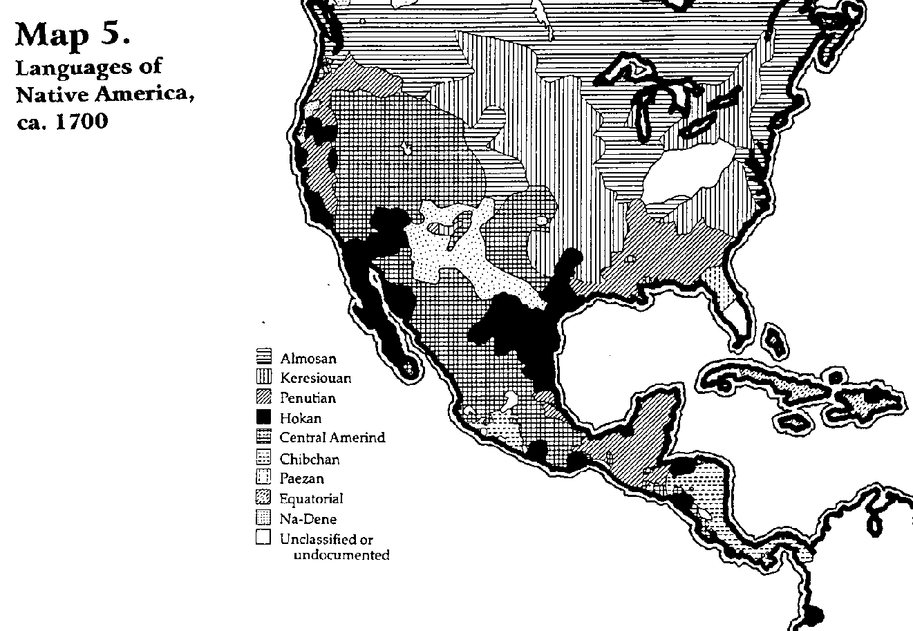
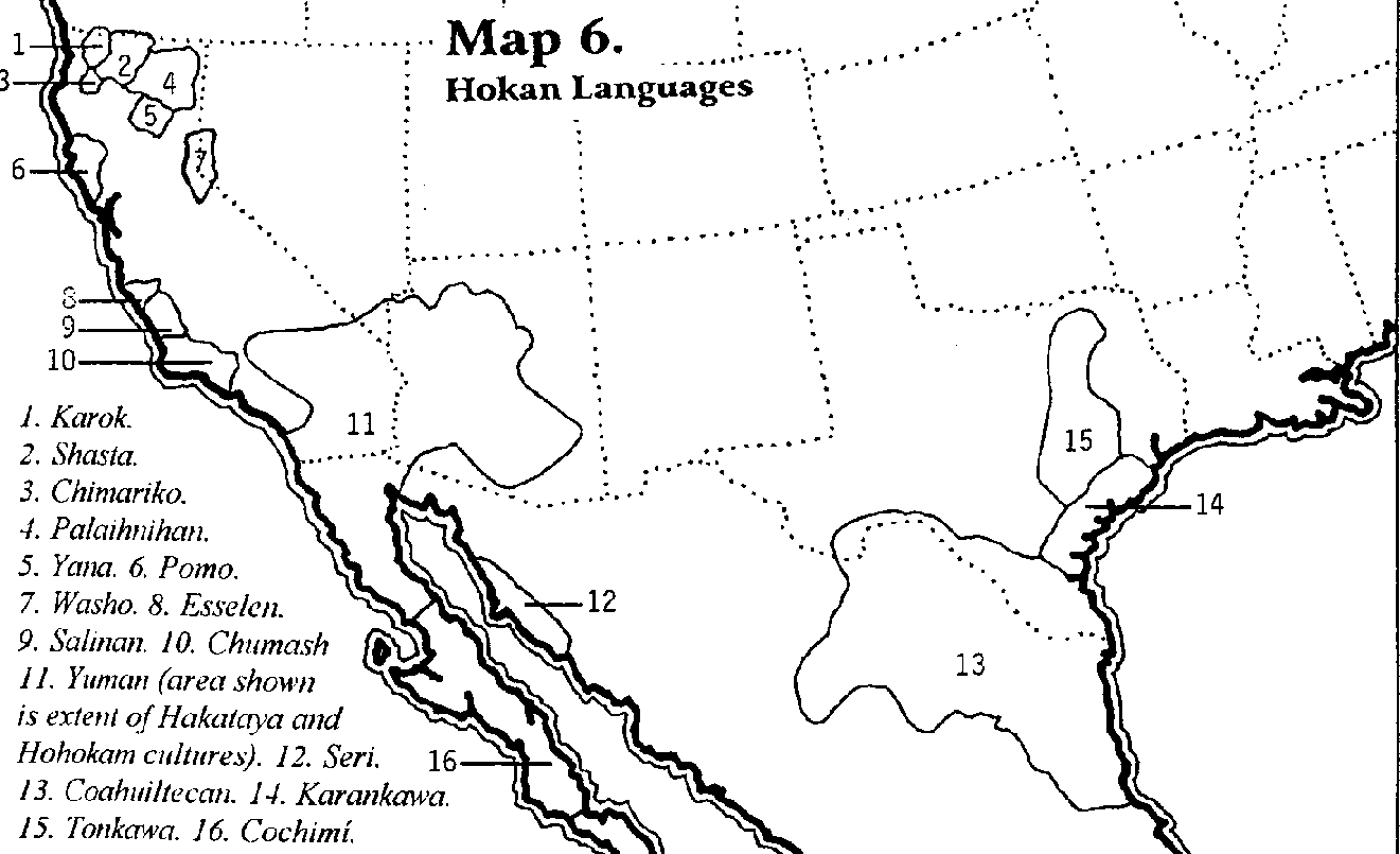
The term "Hokan" unites as genetically related a number of North American Indian linguistic stocks, scattered over a large area and previously considered distinct. Speakers of the Hokan languages are spread throughout California, Arizona, New Mexico, Baja California, Texas and northern Mexico; with outlying groups in southern Mexico, El Savador, Nicaragua, Honduras and Columbia. None of the Hokan languages are well known, but some of the important ones include Achomawi, Karok, Chimariko, Pomo, Yana, Diegueno, Washo, Tonkawa, Havasupai and Maricopa.
Using wordlists and dictionaries, R. Ben Madison was able to establish an impressive list of common words between Berber and Hokan: "I only picked words whose meanings in the two languages were IDENTICAL or very close. These include not just simple nouns, but also verbs, pronouns and numerals -- the kind of words that PROVE genetic relationship. There are HUNDREDS of truly remarkable resemblances. Of course, if you think this is all coincidence, simply compare the English words to the Berber or Hokan words and find how many English words match up. Virtually none of them do. Why? Because English isn't related to Berber or Hokan, but BERBER AND HOKAN ARE RELATED TO EACH OTHER" or, the Mound-builders of the Mississippi Valley and the Hokan peoples are one and the same.
The Canaanite Connection
We have traced the Aztec origins from the Valley of Mexico back to the Hopewell culture of the Mississippi Valley. The question now is: Where did the Hopewell (Mound-Builder) culture come from? For the answer to this question we must turn to the pages of the Bible. In Joshua 3:9 we read:
So Joshua said to the children of Israel, "Come here, and hear the words of the Lord your God." And Joshua said, "By this you shall know that the living God is among you, and that He will without fail DRIVE OUT from before you the CANAANITES and the Hittites and the Hivites and the Perizzites and the Girgashites and the Amorites and the Jebusites...(New King James Version)
Later on, in Joshua 11, verses 16-17 and 23, it is recorded that "Joshua took all the land: the mountain country, all the South, all the land of Goshen, the lowland, and the Jordan plain -- the mountains of Israel and its lowlands, from Mount Halak and the ascent to Seir, even as far as Baal Gad in the Valley of Lebanon below Mount Hermon...So Joshua took the whole land, according to all that the Lord had said to Moses; and Joshua gave it as an inheritance to Israel...Then the land rested from war."
Again, in Deuteronomy 7, we read --
When the Lord your God brings you to the land that you are about to enter and possess, and He DISLODGES many nations before you -- the Hittites, Girgashites, Amorites, Canaanites, Perizzites, Hivites, and Jebusites, seven nations much larger than you -- and the Lord your God delivers them to you and you defeat them, you must doom them to destruction: grant them no terms and give them no quarter...this is what you shall do to them: you shall tear down their altars, smash their pillars, cut down their SACRED POSTS [TOTEM POLES], and consign their images to the fire....You shall destroy all the peoples that the Lord your God delivers to you, showing them no pity....The Lord your God will DISLODGE these peoples before you little by little; you will not be able to put an end to them at once, else the wild beasts would multiply to your hurt. The Lord your God will deliver them up to you, throwing them into utter panic until they are wiped out. He will deliver their kings into your hand, and you shall obliterate their name from under the heavens...(Deuteronomy 7:1-2, 5, 16, 22-24, Tanakh).
When Joshua and the Israelites crossed the Jordan River just north of the Dead Sea, they camped a while at Gilgal, then moved to take Jericho and Ai. Afterward, they returned to Gilgal (Joshua 1-8). After making peace with Gibeon, Joshua led the Israelites through the Valley of Aijalon and defeated the five Amorite kings (Joshua 9-10). From Makkedah, Joshua launched a SOUTHERN campaign against Lachish, Hebron, Debir and Gaza.
Those of the inhabitants who were not put to the sword by the Israelites, FLED TO EGYPT and sought refuge there. Samuel Purchas, in his book Relations of the World and the Religions Observed in All Ages, records this flight: "Procopius...affirms, that all the seacoast, in those times, from Sidon to Egypt, was called Phoenicia: and that when Joshua invaded them, they [those that weren't killed] LEFT THEIR COUNTRY, AND FLED INTO EGYPT..." (1613. Book I, chapter XVIII, p. 85).
After a victorious campaign, Joshua and the Israelites returned to Gilgal for a period of time before launching any more campaigns against the Canaanites. The Canaanites who had fled the country, however, pushed further into Africa: "...there [in Egypt] multiplying, [the Canaanites] pierced further into Africa; where they POSSESSED ALL THAT TRACT, UNTO THE PILLARS OF HERCULES, speaking half Phoenician" (ibid., same page).
Close to the Pillars of Hercules, on the African side, the vanquished Canaanite refugees built two cities: "They [the Canaanites] BUILT THE CITY OF TINGE AND TANGER IN NUMIDIA, where were two pillars of white stone, placed near to a great fountain, in which, in the Phoenician tongue, was engraven: WE ARE CANAANITES, WHOM JOSHUA THE THIEF CHASED AWAY" (ibid., same page).
In The Complete Works of Josephus, translated by William Whiston, is a footnote on page 110 that corroborates Puechas' record --
Moses Chorenensis sets down the FAMOUS INSCRIPTION AT TANGIER [TANGER] concerning the old CANAANITES driven out of Palestine by Joshua thus: "We are those exiles that were governors of the Canaanites, but have been driven away by Joshua the robber, AND ARE COME TO INHABIT HERE." -- Grand Rapids: Kregel Publications, 1988.
In time, these inhabitants of Northern Africa became known as BERBERS and MOORS.
This wave of Canaanite refugees from Joshua's southern thrust expanded rapidly and made their way into the Iberian Peninsula and France -- settling thickly in the Aude, Herault and the lower Rhone. Here, with their "tastefully decorated" pottery, they survived into Roman times, especially the Tolosati, who lent their name to the city of Tolosa (French: Toulouse); and the Tolossae, who lived in what is now Provence. "That the tribes of this region were not Celtic [Israelite] (as is often supposed) is revealed by the fact that the Celtic Gauls -- who always called themselves the Com-broges, or 'fellow-countrymen' (whence Cymru, "Welsh") -- referred to one of the local tribes as Allo-broges, or 'other-countrymen,' i.e. 'non-Celts'" (The Berber Project, p. 7).
In the Iberian Peninsula itself these Canaanites (known in archaeological parlance as the "Beaker Folk") became famous for their concentration of motillas, which were a kind of fortified BURIAL MOUND (Iberian Prehistory, by Maria Cruz Castro. Oxford: Blackwell, 1995. P. 106f). The BUILDING OF MOUNDS was a HALLMARK of Berber and Berber-inspired cultures wherever they migrated to. Writes R. Ben Madison --
Known today among African Berbers as djidar (Ucel, 67f; this appears to be as Arabic word), these mounds were built not only in Africa but throughout the first Berber expansion known as Megalithism. While the ancient cultures of the Eastern Mediterranean buried their noble dead in rock-hewn tombs, the Megalith-builders built rock tombs but sealed them inside large earthen mounds (MacKie, 146). The Berber Project, p. 7.
The Beaker Folk's BEAKERS were, it turns out, more famous than their mounds. Their beakers were drinking vessels -- pottery versions of what had long been woven in North Africa out of esparto grass (The Prehistory of the Mediterranean, by D. H. Trump. New Haven: Yale, 1980, p. 155). They were used for "something like mead, flavoured with herbs such as meadowsweet or wild fruits" (Cunliffe, 253). Alcoholic drinks were clearly a factor in the Canaanite/Berber/Beaker Groups' expansion and social acceptance. McBurney notes that in North Africa the Berbers produced beakers in EXACTLY the same style and fashion as their European contemporaries (The Stone Age of Northern Africa. London: Penguin, 1960, p. 249ff). They decorated them with distinctive "hatched triangles" and other designs; and the classic Beaker design was rather bell-shaped, so most Beaker People (according to the archaeologists) are referred to as "Bell-Beaker People." "This," adds R. Ben Madison, "is in distinction to the 'Funnel-Necked Beaker People,' who arose in Germany and Denmark as a fusion between Berbers and immigrant Indo-Europeans."
The Beaker Folk were fundamentally TRADERS, and wherever they went they were welcomed as friends -- not as hated conquerors. They formed stable outposts, and archaeology has revealed that their tombs contain multiple generations of family members. One archaeologist's (Trump) research indicates that the Canaanite Beaker people tended not to settle in large numbers, except in certain places such as the Rhone valley and the Gulf of Lyon region -- particularly Toulouse. What they lacked in population density, however, they made up for in geographic reach. Writes Madison --
The Berber Beaker People established complex trading networks, and the diverse regions of Western Europe and North Africa were united as never before (Cunliffe, p. 256). Ivory and ostrich egg shells were highly prized luxuries, and the only source was North Africa, where eager Berber traders did a booming business (Markotic, 91ff). Indeed, the trade between Africa and Spain even predated the Beaker period (Harrison, 157). Of more importance to our story was their lucrative COPPER TRADE: they brought chalcolithic culture to Western Europe (Trump, 148f) and to do so, imported vast amounts of copper. -- The Berber Project, p. 8).
As time went by, the Canaanite Berbers of North Africa moved in a different direction from their European counterparts. Preoccupied by local affairs, they blocked the northward expansion of a thriving Black civilization based in the Tassili mountains of southern Algeria. Utilizing superior technology, the Berbers took control of the arid Saharan steppes, exploiting it for nomadic pastoralism. Their new technology and stratified society "enabled them to subjugate the existing black population...[W]e are dealing here with a WARRIOR ARISTOCRACY which had gained ascendancy over the black groups of the Sahara: this is the first instance of a pattern which has been repeated to the present day" (The Berbers, by Brett & Fentress. Oxford: Blackwell, 1996, p. 17ff).
In the meantime the Beaker Berbers of the Iberian Peninsula had begun to decline. However, a few isolated groups remained active, such as the inhabitants of the Balearic Islands who were building fortified towers known as TALAYOTS. These so-called "Talaiotic" people survived well into the Christian era. Archaeology shows that a similar culture flourished next-door in the island of Sardinia. The native, pre-Roman inhabitants of this island were, all evidence indicates, Canaanite Berbers (see The Romance Languages, by Harris and Vincent and Le Origini delle Lingue neolatine, by Carlo Tagliavini). If the ancient Balearans were also Berbers -- which is extremely likely -- then the name of their towers (TALAYOTS) may preserve an indication of what these peoples called themselves.
The Lure of Copper
When the Canaanite-Beaker people rolled across Western Europe from North Africa, they knit that region together by a NETWORK OF TRADING POSTS. The Berbers were an active sea-going people, known for their long distance ocean voyaging. On the boats that they built they used animal skins for sails and, after a while, a great shortage of skins for the leather sails threatened to interrupt their maritime activities. This problem was solved by a group of Berbers who set up a large hunting camp in Arctic Norway near Mount Komsa in Finnmark. From here they annually took large numbers of reindeer out of the herds migrating through the area and sent the skins to the oak forests of southern Sweden and Conamara in Ireland for tanning with oak bark. Other trading posts appeared in the amber-rich areas of the Baltic.
In their merchantile voyages and through their Megalithic contacts, the Berbers became aware of the presence of vast deposits of COPPER in the New World. "Beaker Groups, keen to exploit copper deposits wherever they could be found, began to navigate to the New World. They possessed a geographical advantage...the easiest route to North America was the Atlantic Current from Iberia or North Africa to the Caribbean (Kehoe, 280)....North America was...treated to a large and substantial wave of Berber immigrants who brought their culture with them when they settled around the copper mines of Lake Superior and northern Wisconsin" (The Berber Project, p. 12).
The Canaanite/Berber/Beaker colonists were traders to the very core! They came in search of wealth and found it in copper -- huge amounts of it around Lake Superior and on Ile Royale, which is reputedly the best source of pure copper on the entire planet! The sudden emergence of what archaeologists have called the "Old Copper Culture" coincides with large numbers of Berbers who descended on the American Midwest and the St. Lawrence River valley to exploit these new-found riches.
Hu the Mighty
Why this "sudden emergence" of the Old Copper Culture in North America? Why this sudden wave of Berber immigrants to the areas of Lake Superior and northern Wisconsin? What major event in Western Europe and the Iberian Peninsula could have caused this sudden influx of peoples to the New World?
Shortly after the fleeing Canaanites became ensconced in Western Europe and the Iberian peninsula, another great migration took place that was to once again uproot the vanquished descendants of Canaan! In the Welsh TRIADS (traditional chronicles) we find mentioned a mysterious man by the name of HU THE MIGHTY, who led a group of settlers from the Middle East to the isles of Britain.
E. Raymond Capt tells the story:
...Hu Gardarn Hyscion (Isaacson?) or "HU THE MIGHTY," led a party of settlers from Asia Minor to Britain. A DESCENDANT OF ABRAHAM, Hu the Mighty's coming to Britain provides one of the first recorded instances of the fulfillment of the prophecy found in Genesis 28:14; that the "seed" of Abraham would spread abroad, to the four points of the compass. The Welsh Triads, or "traditional chronicles," give evidence of Hu the Mighty coming from Asia Minor. In the Welsh Triad 4, we read that: "The first of the three chieftains who established the colony was Hu the Mighty, who came with the original settlers. They came over the Hazy Sea from the summer country, which is called Defrobani, that is where Constinoblys now stands." -- Stonehenge and Druidism. Thousand Oaks, CA: Artisan Sales, 1979, p. 75.
Who was this Hu Gardarn -- "Hu the Mighty," a descendant of Abraham? Herman L. Hoeh reveals the answer --
When and how did the Children of Israel [first] migrate to Western Europe? The answer is found in Cymbric or Welsh history.
A fragmentary Welsh record, called the Welsh Triad, reads as follows: "First was the race of the Cymry, who came with Hu Gadarn to Ynys Prydain." Hu came from "the land of Summer" -- a land located somewhere in what later constituted the realm of Constantinople (the capital of the eastern Roman Empire). He journeyed to Ynys Pridain -- the Welsh name of the isle of Britain. This first major settlement preceded the migration in 1149 [B.C.] of Brutus of Troy to Britain.
Who was Hu Gadarn? Gadarn is a Welsh word. It means the "Mighty." Hu was a short form of the old Celtic name HESUS (Origines Celticae, by Edwin Guest, vol. 2, p. 9). HESUS is the Celtic -- and also the Spanish pronounciation of JESUS. Was there a famous "JESUS" who lived in the balmy summerland of the EASTERN MEDITERRANEAN centuries BEFORE the time of Jesus the Christ? Most certainly! It is found in Hebrews 4:8, "For if JESUS (that is, JOSHUA) has given them rest, then would he not afterward have spoken of another day?"
Jesus was merely the Greek form of the Hebrew name JOSHUA. Hu or Hesus the Mighty was JOSHUA THE MIGHTY, the great general who led Israel into Palestine. And the Welsh Triad records that in his LATER YEARS he also settled Israel peaceably in the British Isles. From there, for trading purposes, they spread to the coasts of the Continent which were subject to the German Cymry -- the descendants of the German king Cimbrus (1679-1635). -- Compendium of World History. Pasadena, CA: Ambassador College, 1963, pp. 48-49.
Settling Israelites in Britain was not the only concern of Hu the Mighty or Joshua. To the end of his life he was faithful to the commands of YEHOVAH God regarding the people of Canaan. It is recorded that in the third year of Romus, son of Testa and king of SPAIN, a man by the name of "Liber Pater" or Bacchus (Iacchus) CONQUERED SPAIN and brought it under his sway. "He was from the EAST. His title belonged to HESUS THE MIGHTY of Celtic tradition. Hesus was Joshua (Jesus in Greek).
"HE PURSUED THE CANAANITESAND DROVE THEM OUT OF WESTERN EUROPE" (ibid., pp. 122-123). This occurred in 1430 B.C. -- see volume II of the Compendium of World History.
This was the root cause of the large influx of Canaanite Berbers who descended on the American Midwest and the St. Lawrence River valley. While some of the Canaanites were pushed north to the far-reaches of Norway and Sweden, the majority fled across the Atlantic as Joshua overran the Iberian Peninsula.
The Copper Culture
The chief artifact or product of the Old Copper Culture was, of course, the metal Copper. A vast number of copper tools suddenly appear in the archaeological record without any antecedent. Ronald J. Mason remarks: "Incredible numbers of copper artifacts -- tens of thousands in eastern Wisconsin alone -- attest to a use of the metal that is at variance with historical and ethnographic descriptions of Indian life" (Great Lakes Archaeology. N.Y.: Academic Press, 1981. P. 12). The amounts of copper mined from these areas is mind-boggling -- an estimated 500,000 pounds! Since only a very small amount of this total can be accounted for in New World archaeological sites, WHERE did the rest of it go? To the Old World, to fuel the growing "chalcolithic" economies of the Mediterranean civilizations.
The Berbers who settled the New World left records of their sudden appearance: sculptured stones closely resembling those found in the Berber-speaking Canary Islands have been found north of Lake Superior. The resemblance was so strong that some scholars suggested the Canary Islanders originated in America!
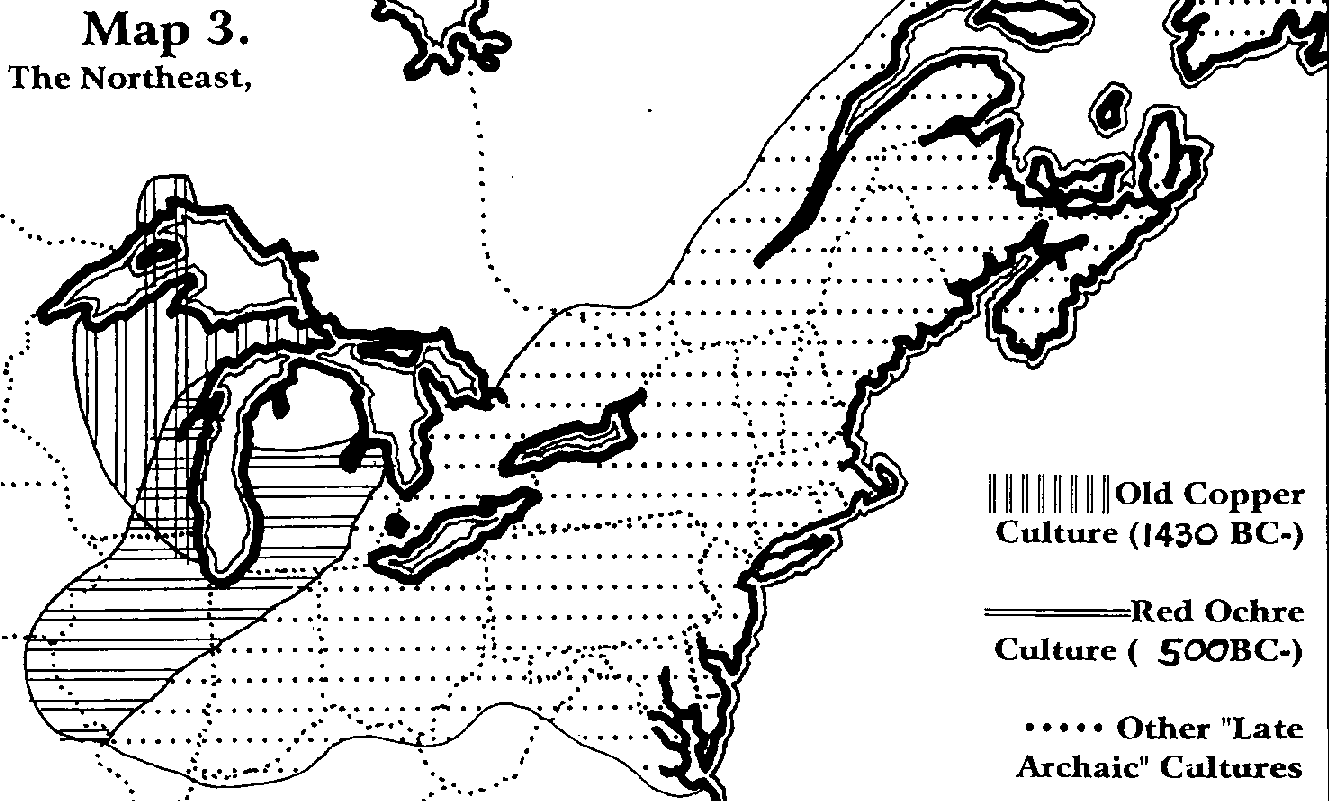
The Old World Canaanite-Berber Culture and the New World Old Copper Culture can be directly compared --
New World Copper Culture
1/. Arose circa 1430 B.C.
2/. Flexed burials (Wisconsin Archaeologist, 67: 225)
3/. Burial in mounds (WA 67: 229)
4/. Cremation (WA 67:225)
5/. Burial with stone arrowheads (WA 67:221)
6/. Burial with copper daggers (WA 67: 220)
7/. Burial without pottery (WA 67: 234)
8/. Bow-shaped pendants (WA 67: 219f)
9/. Hunter-gatherers (WA 67: 227)
10/. Red ochre in burial (WA 67: 229)
11/. Wrist-guards (WA 67: 222)
12/. Copper mining using fire and water (WA 67: 220)
13/. "Annealed" (tempered) copper (WA 67: 220)
Canaanite-Berber Group Culture (especially in North Africa)
1/. Driven out of Spain 1430 B.C.
2/. Flexed burials (Schutz, 120f)
3/. Burial in mounds (Cunliffe, The Oxford Illustrated Prehistory of Europe, 251ff)
4/. Cremation (Schutz, 120f)
5/. Burial with stone arrowheads (Harrison, The Beaker Folk, 92ff)
6/. Burial with copper daggers (Harrison, 111)
7/. Burial without pottery (Mokhtar, General History of Africa, 435).
8/. Bow-shaped pendants (Harrison, 51f)
9/. Hunter-gatherers (Harrison, 23 & 100)
10/. Red ochre in burial (Camps, Monuments et rites funeraires protohistoriques, 521ff)
11/. Wrist-guards (Harrison, 9)
12/. Copper mining using fire and water (Schutz, 127f)
13/. "Annealed" (tempered) copper (Schutz, 127f)
Odin and the Canaanites
Another migration into Europe was to occur that would replenish the Canaanite stock that had fled across the Atlantic and to the Northern reaches of Scandinavia.
Shortly after Joshua planted the Israel people in the British Isles, the region of Scandinavia (and particularly the peninsula of Denmark) became a chief area of trade and commerce on the Continent. It was strategically located to dominate both the North and Baltic sea trade. So, living together with the original German tribes of the Cymry and Dauciones were migrants from Britain -- the HEBREW CYMRY transplanted by Hu the Mighty or Joshua of Jericho fame. "In 1040 [B.C.]," relates Herman L. Hoeh, "the HEBREW CYMRY called for a descendant of Judah, a royal scion of the House of Troy, to rule over them." "ODIN," continues Hoeh, "answered the call and led a MIGRATION out of Thrace into Denmark and neighboring regions" (Compendium of World History, vol. II. Pasadena, CA: Ambassador College, 1963, p. 50).
Also known as Woden, Wotan and Dan, Odin is the foremost hero of Norse mythology and, as such, was worshipped by the pagan forebears of the Anglo-Saxons, the Scandinavians, the Germans and THE CANAANITES in their midst! Human sacrifices were frequently offered to Odin, especially prisoners taken in battle; and the worship of Odin appears to have prevailed chiefly, if not solely, in military circles. He was known to the Anglo-Saxons as WODEN, and to the Germans as WODAN (WUOTTAN).
The magazine Wake Up!, in its August, 1980 issue, explains that "whilst such deification of ancestors can only be deplored, there is firm reason to assert that Odin was a mighty leader of the Israel people during their westward trek from ancient Scythia [which included Thrace] -- the region to the north of the Black and Caspian Seas -- towards the fringe countries of the North Sea" (London: Covenant Publishing Co., p. 18).
At this point we should digress a little and locate the area known as "THRACE." This will help us to understand the migrations of the Canaanites who fled from Joshua and the Israelites and, at a later date, were led from Thrace to northwestern Europe under the leadership of Odin or Dan I of the house of Judah.
"Thrace," notes the Encyclopedia Britannica, "[is] a name applied at various periods to areas of different extent....The boundaries of the Roman province of Thrace were -- north, the Haemus; east, the Euxine Sea [Black Sea]; south, the Propontis, the Hellespont and the Aegean; and west, the Nestus. The distinguishing features of the country were the mountain chain of Rhodope (Despotodagh) and the River Hebrus (Maritza)." "The Hebrus," continues the Britannica, "with its tributaries, drains almost the whole of Thrace" (1943 edition. Vol. 22, p. 159). The earlier Thrace or Scythia covered a wider area than during Roman times.
The 1946 edition of the Britannica describes the people who anciently inhabited this region. In the article on Thrace, we read --
The name Thrace, because it has been used as a geographical term as well as an ethnic description, has added to the confusion. Thrace was inhabited by indigenous tribes, as well as by Celtic [Israelite] tribes such as the Getas. The aboriginal inhabitants were the RED-SKINNED THRACIANS mentioned by the Greek writers and they differed from the Celtic tribes not only in COMPLEXION but also in customs and religion. -- Herodotus, V. 14.
The native Thracians were called RED-SKINS by the Greeks!
The Britannica continues --
The most outstanding archaeological monuments of the prehistoric period are the MOUND-LIKE TOMBS, that were generally located in the outskirts of the ancient cities....There is no well-defined difference between the aboriginal Thracians and the native Illyrians. All of the Thracian tribes and the Illyrian tribes practiced TATTOOING, which distinguished them from the Celtic tribes that had from time to time dominated them.
In the 1911 edition of the Encyclopedia Britannica we find the following --
Herodotus and other Greek historians portrayed the Illyrians as a semi-savage people; they viewed them as the most savage tribes of Thrace. Both peoples they described as practitioners of the art of tattooing. They painted their bodies and SACRIFICED HUMAN VICTIMS to their gods. The women of Illyria occupied AN EXALTED POSITION in tribal society and even EXERCISED POLITICAL AUTHORITY. The queens are referred to as despots or royal personages. -- Vol. XIV, p. 326.
These are very important points to remember -- the people of Illyria practised the very same customs we find among the Picts of Europe and among the Aztecs of Mexico!
If we go again to the Encyclopedia Britannica, we find that the inhabitants of Thrace were men of RED SKIN! Herodotus adds that the Thracians resembled the people of Illyria ("Thracia," ibid., vol. XXVI, p. 886).
The weight of all the evidence we have just examined plainly indicates that the Picts (the northern Canaanites), on beginning their march to Europe and the British Isles, departed from the region that included the ancient territory of Scythia -- and later the territories of Thrace and Illyria. "From this area came the American Indians who the Europeans found inhabiting this continent when they arrived!" (The Roots of the American Indian, p. 49).
Notes Herman L. Hoeh --
It was FROM THRACE that Odin led the Agathyrsi and other tribes to northwestern Europe when he founded the Danish kingdom. Many of the warriors employed by the early princes of western Europe were FIERCE, OF SWARTHY SKIN, NAKED AND OFTEN TATTOOED AND PAINTED. Strabo, the Roman geographer, wrote that areas of Ireland and Britain were inhabited "by MEN ENTIRELY WILD." Jerome, writing in one of his letters in the fifth century, characterizes some of them as CANNIBALS. -- Compendium of World History, vol. II, p. 86.
With Odin, then, when he migrated from Thrace to the area of Scandinavia, was a MIXED THRONG of people -- including the Pactyae or Picts who were descendants of the CANAANITES Joshua drove out of the Promised Land. Thus the Berber-Canaanite stock that was driven out of Europe by Joshua was replenished by the Pict-Canaanites that Odin brought with him from the area of Thrace.
David and the Copper Mines of America
Following the recapture of the city of Troy in 1149 B.C., many groups of peoples -- conquered as well as conquerors -- sought new homes in the Iberian Peninsula. After 1149 the Lydians (forebears of the Etruscans) dominated the Mediterranean region -- heading the list of Thalassocracies or Sea Powers. Each of the Sea Powers in turn dominated Spain until Nebuchadnezzar the Great made Spain a part of the Chaldean Empire for nine years. Following that, the people of Gades in Spain invited the Carthaginians to come and rule over them. The Carthaginians remained until they were expelled by the Romans in 201 B.C.
In the Spanish histories of the Sea Powers there is a strange gap between the Lydians (1149-1101 B.C.) and the THRACIANS (970-884 B.C.) which, according to Herman Hoeh was "deliberately inserted in this list. It is similar to attempts elsewhere to expurgate any record of the PELASGIANS, who were the HEBREWS of the Kingdom of Israel. The missing item should be
Pelasgians 131 1101-970
"This list indicates that the Hebrews became dominant in Spain at the time the Lydians resettled in the Grecian world in 1101" (Compendium Of World History. Vol. II. Pasadena, CA: Ambassador College. 1963, p. 125).
Another interesting fact about this period of time is the dates of the Pelasgian influence in Spain -- 1101-970 B.C. If you haven't realized it already, this was the time-frame of David and Solomon's reign in Israel!
David was at the height of his power, and there was no nation left with the means to challenge him. His attention now turned to his personal goal of building a great temple to honor the God of Israel. While God did not allow David to actually build the Temple, he was allowed to make preparations for its construction that was carried out during the reign of his son Solomon. These preparations, the Bible reveals, were prodigious indeed! With vast war booty and tribute payments pouring in from vassal nations, David was now able to access the raw materials he needed for the Temple project -- using the help of his Phoenician and Pelasgian allies.
David's prodigious Temple preparations and his instructions to Solomon are recorded in I Chronicles 22: 1-16. Relates Steve M. Collins --
David accumulated "great stores of iron for nails and clamps" (RSV), showing that what secular historians have called the "iron age" was well under way by the beginning of the first millennium B.C. He also accumulated "bronze in quantities beyond weighing," (RSV) so David also accumulated massive stockpiles of copper ores and refined copper products for Solomon to utilize in his reign. He also amassed much cedar wood through his alliance with the city-states of Tyre and Sidon. In the course of his wars, David had collected large amounts of gold and silver from tributary nations, and verse 14 quotes David as summing up his temple preparations with these words:
"With great pains I have provided for the house of the Lord a hundred thousand talents of gold and a million talents of silver, and bronze and iron beyond weighing, for there is so much of it; timber and stone too have I provided." (RSV). -- The "Lost" Ten Tribes of Israel...Found!, p. 24.
This brings to mind one very obvious question -- WHERE did all this copper ore come from? Since the amounts of gold and silver were weighed ("a hundred thousand talents of gold" and "a million talents of silver"), the copper and iron stockpiles obviously had to far exceed the precious metals stockpiles to be considered "beyond weighing." How many millions of talents of iron and copper ores, then, were amassed to reach an amount "beyond weighing"? Apparently such a vast amount of copper and iron ores could not have all come from sources that were indigenous to Israel. However, since David was on friendly terms with the Phoenician city-states of Tyre and Sidon, he could have had the Phoenician merchant ships import the ores from overseas. "Phoenician [or Canaanite] ships dominated the commerce of the Mediterranean Sea and they sailed into the Atlantic Ocean to reach ports in Western Africa and Northwest Europe. Just how far into the Atlantic did they sail?" (ibid., p.25). How far, indeed?
In the book Bronze Age America, the late Dr. Barry Fell (Professor Emeritus of Harvard University) records that copper trading between ancient North America and the Old World was extant prior to and DURING THE REIGN OF KING DAVID! "His book cites evidence from ancient inscriptions that Norse kings carried on a copper trade with the New World in the St. Lawrence River as early as 1700 B.C., seven centuries prior to the reign of King David over Israel" (ibid., p. 25). This begs the question that if ancient Old World civilizations traded with the inhabitants of North America -- could the seafaring Phoenicians have been far behind?
There is, in fact, clear evidence that David's allies, the Canaanite Phoenicians, were indeed included in the New World copper trade and that some of David's huge stockpile of copper ore came from the Phoenician's North American trading routes. Notes Barry Fell --
There is also quite independent...reasons for thinking that ancient European voyages came to America. Thet concern the mining of metals.
For the past twenty years leading mining engineers and university metallurgists have been seeking from archaeologists an explanation of a most baffling mystery in the history of mining technology. So far no answer has been found.
Around the northern shore of Lake Superior, and on the adjacent Ile Royale, there are approximately 5,000 ancient copper mine workings. In 1953 and 1956 Professor Roy Drier led two Michigan Mining and Technology expeditions to the sites. Charcoal found at the base of the ancient mining pits yielded radio carbon dates indicating that the mines had been operated between 2000 B.C. and 1000 B.C...The most conservative estimates by mining engineers show that at least 500 million pounds of metallic copper were removed over that time span, and there is no evidence as to what became of it. Bronze Age America. NY: Wallaby, 1976, p. 261.
Since radio carbon dating can be inaccurate in this time frame, we should lower the dates. However, it would still fall into the time of King David and Solomon's reigns over Israel. Since the mining operations at these North American sites were taking place during the reigns of David and Solomon, it is more than likely that part of this Lake Superior copper was used to satisfy David's voracious appetite for raw copper for the Temple. The biggest customers for copper and other raw materials in the world of the time were King David and Israel and, later, King Solomon. It is well-known that Solomon's building projects went far beyond anything that David himself envisioned -- so the demand upon the available world sources of raw materials during their reigns must have been huge indeed! The local mines could not have supplied all the ore required at the time. With this in mind, it is significant that these ancient Lake Superior copper mines were worked to exhaustion during the reign of King Solomon, meaning that they were producing during the time that David was stockpiling copper ore "beyond calculation" for the construction of the Temple in Jerusalem! "Since the North American copper mines had been known to the Old World for centuries before David lived, and since there is evidence that Phoenician ships called at ancient North American ports, the means to transport Lake Superior copper ores to King David of Israel did exist" (The "Lost" Ten Tribes of Israel...Found!).
The observation of Barry Fell that "there is no evidence as to what became of it" (meaning that there is no evidence that this ancient North American copper was used in ancient North America) can now be answered from God's Word. The Bible plainly indicates that ancient Israel, under King David, was stockpiling massive quantities of copper ore around 1,000 B.C. -- secular sources have confirmed that the North American copper mines ran out of ore during the reign of Solomon. The connection between the two is very obvious: most of the ancient North American copper ore was shipped to ancient Israel and used for the construction of the Temple and later projects of Solomon. Notice the following quotation from Barry Fell's book --
Archaeologists have maintained that there was NO Bronze Age in Northern America and that no contacts with the outside world occurred. On the other hand the mineralogists find themselves obliged to take a DIFFERENT VIEW: it is impossible, they argue, for so large a quantity of metal to have vanished through wear and tear. And since no large numbers of copper artifacts have been recovered from American archaeological sites, they conclude that the missing metal may have SHIPPED OVERSEAS. -- Bronze Age America, p. 261).
It must remembered that the Canaanite Phoenicians had the primary maritime shipping fleet at the time, with ports in Pelasgian (Israelite) Spain. Since King David was closely allied to the Phoenicians, he would have received preferential allocation of whatever was being shipped from the New World in Phoenician ships.
The Role of Poverty Point
At the very same time -- circa 1,000 B.C. -- we find the construction of the first real "city" in the United States -- at a site archaeologists call "POVERTY POINT," along the Mississippi River in Louisiana. "Here," according to Lynda Schaffer, "Berber-style MOUND-BUILDING in the New World begins with startling suddenness" (Native Americans Before 1492, p. 6).
Poverty Point was a TRADING CITY, called by some a chalcolithic Berber Singapore, through which the copper wealth of the Mississippi River and the Great Lakes was funnelled. Copper from Lake Superior, notes Ronald Mason, made it all the way to the Gulf Coast and eventually to the Old World; and north-south trade with the "Red Ochre Culture" is abundantly proved by the Wisconsin Archaeologist. Observes R. Ben Madison --
Utilizing Megalithic ideas, Poverty Point's mounds were aligned so as to predict the vernal and autunmal equinoxes. At its peak, between 1000 and 700, Poverty Point had a population of over 5,000 people. Its direct territorial control took in the Mississippi Valley in Mississippi, Louisiana and southern Arkansas. The modern name, "Poverty Point," is most unfortunate; it was an enormous and thriving city -- perhaps "Prosperity Point" would be more appropriate. Interestingly, the city was divided into TWO DISTRICTS, indicating some kind of SOCIAL DISTINCTION. -- The Berber Project, p. 14.
The Phoenician ships with their Israelite traders/buyers used this port on the Mississippi for buying the ore that was transported down the river from Lake Superior and the Isle Royale. The fact that Poverty Point was divided into two districts points to a Canaanite-Phoenician/Berber quarter and a quarter for the Israelites who traveled on the Phoenician ships. Evidently, a large quantity of the copper ore stockpiled by David for use in the Temple passed through Poverty Point. Later, David's son Solomon continued importing the ore from Lake Superior for his grandiose building projects -- until it was finally exhausted.
The Invasion of the Celts
The Old Copper Berbers mined copper and their population multiplied for almost 1000 years before a major revolution took place. Back in Europe the Berbers of Iberia and Western Europe were eventually reduced to little more than a collection of place names after a massive invasion of Celts erupted from the east. These Celts, which careful research shows were migrating Israelite tribes from the Black Sea area, spawned a culture known to the archaeologists as the Hallstat-La Tene Culture. Emerging in central Europe and exploding to the west some fifty years later, the Celts pushed the Canaanite Berbers to the far north regions of Norway, Finland and Russia. A few pockets remained in the Basque areas of Europe and in Pictland in northern Britain.
The Canaanite-Berber cultures of Western Europe were savagely disrupted by the invading Israelites (Celts). Refugees -- first a trickle, then a flood -- began to flee from the ceaseless predations of this migrating people from the East. Thousands boarded their boats and set sail for the New World; and a massive surge of Berber immigration to North America from North Africa and the Iberian Peninsula was underway -- as proven by a myriad of cultural innovations from the Beaker Group culture which burst upon the North American scene. Professor Barry Fell dates a MAJOR WAVE of "Iberian" (i.e. Canaanite-Berber) colonists to the New World to this period (America B.C., front piece).
Explains R. Ben Madison --
At this point in the archaeological record, Berber cultural traits appear suddenly and mysteriously all across the eastern United States and in the Caribbean. North African bent-stick and split-stick hafting techniques for grooved stone axes, for example, spread throughout the region. Agriculture, pottery, earthen mounds, and "new artifacts" arrived suddenly (Mason, 202). In Central America, pottery dating from this period is virtually identical to that being produced by North African Berbers (Kennedy 1971, 270f). All over the northeastern part of North America the dominant "Vinette 2" style of pottery shows clear Iberian Beaker influence (Kehoe, 290f). At the same time, The Old Copper Berbers in southeastern Wisconsin, Michigan, Illinois and Indiana began to employ the use of RED OCHRE in their burial rites in large quantities. Archaeologists often refer to this stage of Berber development as a "Red Ochre Culture" (Mason 224). But it is important to note that the Old Copper and Red Ochre "cultures" were in truth a single entity (WA 67: 229; Griffin, 239; Map 3). This use of red ochre in burial rites is, needless to say, a well-known feature of Berber culture (Camps 1974, 173ff). -- The Berber Project, pp. 13-14.
According to the Greek historian Herodotus (484?B.C. - 425B.C.), Berbers wore what we call "Mohawk" haircuts -- like many North American Indian tribes. Herodotus also mentions that the Berbers engaged in the same kind of "vision quest" commonly found in North American cultures (Herotodus: The History, 4: 172ff). "To this day," adds Madison, "Berbers have the same kind of animal legends as North American Indian mythology (Hart, 164f). Berbers had arrowheads, atlatls (spear throwing devices), WORE FEATHERS IN THEIR HAIR, and wore fringed leather clothing, exactly like the Native American peoples of North America (Kennedy 1971, 272f)" (p. 14).
Following this Great Migration around 500 B.C., we are left with three large and substantial Canaanite/Berber groups in the New World. The first -- which had settled around Lake Superior and Wisconsin in approximately 1430 B.C. -- was named the "Old Copper Culture" by the archaeologists. Its continuation, the "Red Ochre Culture," spread through Wisconsin, Michigan, Illinois and Indiana. The second group settled in and around Poverty Point, Louisiana circa 1000 B.C. Finally the third group, which was the third great wave of Berber immigration, arrived shortly after 500 B.C. and was instrumental in the emergence of the Adena Culture
All these groups, explains R. Ben Madison, maintained some contact with their parent civilization, the Beaker groups, back in Europe and North Africa. But when the Celts exploded into Spain and pushed the Canaanite-Berbers out, this disrupted what was left of the Beaker trade with the New World and, at roughly the same time, "for reasons not yet understood," the Isle Royale copper mines were abandoned and there occurred a substantial decline (in the New World) in the use of copper to manufacture everyday tools and utensils. Jim Bailey writes that around Lake Superior, which was a focus of Canaanite/Berber colonization in those days, modern Ojibwe Indian legends say that their ancestors drove out a race of white miners (Sailing to Paradise. N.Y.: Simon & Schuster, 1994. P. 30ff). At the same time that the Celts drove the Berber Beaker culture (also, Picts) out of western Europe, the Poverty Point culture (the Berber Beaker trading outpost in the New World) also collapsed. The reason the Poverty Point culture collapsed is not sure, but it seems its inhabitants dispersed to the West where they became the ancestors of the Tonkawa and other tribes of Texas.
However, one Berber culture in North America survived -- the "Red Ochre" culture in Wisconsin. From this culture (along with the new influx of Berbers from Spain) a new civilization was beginning to emerge -- the ADENA CULTURE.
The Adena Mound-builders
The umbilical cord between Western Europe and North Africa was cut when the Israelite Celts invaded Europe circa 500 B.C. But, like the Phoenix rising out of the ashes, the Berber culture was revived -- and from a different quarter after North Africa and the Iberian Peninsula fell under the influence of Carthage.
According to R. Ben Madison the remnants of the Berber-Beaker culture on the Iberian Peninsula -- now mixed with Celtic or "Celtiberian" peoples -- began to trade with Carthage. The remaining Berber economies such as Talseia (Tarshish) began to decline while, at the same time, the Poverty Point culture faded back into the Louisiana bayou country and its inhabitants fled to Texas. As a result of the situation in Spain, the Berbers returned to the New World in Carthaginian ships to begin regular trade with the American Northeast.
By approximately 200 B.C. the Berber descendants of the Red Ochre Culture expanded into what is now Ohio where, notes Madison, "Libyan Berber colonists were arriving in greater and greater numbers, perhaps to staff the trading posts that sprang up in the river valleys east of the Mississippi, especially the valley of the upper Ohio River in Ohio and West Virginia -- probably the colony Diodorus Siculus wrote about" (The Berber Project, p. 16).
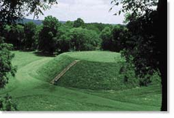
Etowah Mound
At this time a new, Canaanite/Berber-derived culture called "ADENA" began to flower in Ohio. The Adena culture emerged from the Berber-dominated "Red Ochre" tradition -- the descendants of the very people whose ancestors had first mined copper on Lake Superior. "Political leadership in Adena," writes Madison, "was probably provided by Berbers from Africa."
The first well-known "Mound-builders" in American prehistory were the Adena and, explains Madison, "mound-building was an important art in both their Megalithic and Beaker phases." In both North Africa and Western Europe the Berbers buried their dead in stone tombs which were then enclosed in large earthen mounds. Across the Atlantic in North America this Berber custom was continued -- many mound-builder tombs are EXACTLY the same layout, a rock tomb covered in an earthen mound (Radin, The Winnebago Tribe, p. 55).
The historic copper trade apparently continued -- or was revived. Copper ingots of IDENTICAL "ox-hide" shape have been found on both sides of the Atlantic, proving that around 200 B.C. there was a revival of the regular Atlantic trade between the Mediterranean and North America. This involved copper from Wisconsin, set down the Mississippi River and out to Europe. Bruce J. Trigger reveals that there were also Adena sites in Maryland -- suggesting traffic up thr Potomac and Monongahela rivers from the Atlantic into the American interior (Handbook of North American Indians, p. 29).
At roughly the same time, claims Harvard Professor Barry Fell, waves of "Iberian Punic Colonists settled in North America" (Fell 1976, 169ff). Fell's research relies mainly on linguistic findings -- especially in the form of inscriptions. A word of warning: While we can usually trust Fell's identification of a particular alphabet, his translations, unfortunately, leave much to be desired. He is addicted, for some reason, to mixing and blending languages to suit his own purpose and, since he apparently loathes footnotes, it is very difficult to verify his assertions.
Despite his lapses in methology, however, Fell does a real service in relating to us facts that have been documented by others. "In 1838," writes R. Ben Madison, "a Talseian (Iberian) inscription was discovered in Mammoth Mound, an ADENA SITE at Moundsville, West Virginia. It was immediately pronounced by French and American linguists to be Berber, Libyan, or Numidian. The brief inscription explains that the mound was a burial site for a notable named Tadach, and that his wife had it built in his memory. Similar inscriptions are found in other Adena mounds (McGlone, 9ff). This, and another nearby stone inscription, was written in the PUNIC language, in Iberian letters (Fell 1976, 157f). In Oklahoma, a Punic inscription -- apparently some sort of "hymn to the sun" -- was discovered and dated to approximately the time of the first Carthaginian arrival in the New World, while a nearby inscription in Iberian script marks the grave stone of a notable named Haga (Fell 1976, 159f). The Anubis Caves in the Oklahoma Panhandle contains an inscription in Libyan letters which Fell claimed was "Arabic." However, most scholars point out that it is, in fact, Berber. The Iberian/Punic alphabet has also been found on inscriptions in Iowa, Massachussetts, Spain and Lebanon -- showing the Middle East origin of the Mound-builder Berbers.
People of the Old World saw America as simply an overseas extension of North Africa: "Herodotus describes 'a place in Libya,' beyond the Pillars of Hercules (i.e. past the Straits of Gilbralta) where the Carthaginians traded for precious metals. He wrote that the local natives used SMOKE SIGNALS to communicate over long distances -- an obvious reference to the famous Native American custom (Herodotus, 4: 196). Later on, the Vikings, evidently on the basis of the profound and obvious similarities between North American and North African inhabitants, languages and cultures, formed the impression that North America was simply a peninsula of North Africa itself (Riley, 250). -- The Berber Project, p. 17.
What the Mounds Tell Us
The Adena burial mounds themselves give us an exceptionally clear indication of the Canaanite/Berber identity of the Adena culture and its successor the Hopewell Mound-builder culture. Adena was a religious faith: while other tribes had their "earth-bound animal gods," Adena Berbers looked toward the sky. Around the mounds were "Sacred Circles" that served as holy "meeting places" for the people; and the mounds themselves, therefore, served as maraboutic shrines in the time-honored Berber/Canaanite tradition. Explains Madison: "Like Adena society, Berber society in ancient times (and even, in some places, today) was not an organized 'state,' but rather 'a state of nature mitigated by hereditary saints...anarchy mitigated by holiness!' The archaeologists have found that the men buried in Adena mounds were those who 'established their utility to the community through ritual powers and mechanisms of economic exchange, just like the Berber marabout'" (The Berber Project, p. 18).
The dictionaries tell us that the French term marabout refers to a Berber "holy man." The definition adds that the marabout is a holy man with a holy genealogy -- but the genealogy alone does not guarantee his holiness. He can be "holy" if he has baraka -- divine powers, "charisma" in the theological sense. He has magical power, is good and pious, generous, hospitable and peace-making. He accepts donations from those who seek his blessing. "The marabout is not a warrior, but he provides political leadership in times of crisis or to resolve disputes between warring factions" (Ernest Gellner, Saints of the Atlas. Chicago: University of Chicago Press, 1969, p. 74ff). This appears to be the PRECISE ROLE of those buried in the Adena mounds.
Berber religion down through the ages -- whether pagan, Roman, Christian or Muslim -- has retained its characteristics. It has a tendency towards monotheism (the cult of a single great and all-powerful deity) coupled with a veneration for a host of lesser saints and holy men -- the marabouts, or Christian martyrs. Soothsayers, prophets and seers all had popular followings, and pilgrimages have always been made to their shrines. Fatalism and a belief in the influence of evil spirits is prevalent as well, and Berbers show great concern for the dead. Offerings are made for them, libations poured on their tombs and feasts are held for them in cemeteries today. W. H. C. Frend notes that people slept at tombs of ancestors or marabouts in Herodotus' time, in Christian times, and do so at the present day (The Donatist Church: A Movement of Protest in Roman North Africa. Oxford: 1971, p. 76ff).
This concern for the dead was also CENTRAL to the North American Berbers. The Adena burial rites were a mixture of the old and the new; and the bodies of the ruling class and other important people were usually sprinkled with RED OCHRE and laid to rest with a variety of artifacts such as flints, beads, pipes, and mica and copper ornaments. The red ochre aspect of the burials was a practice that extended back for generations through the Old Copper Culture and all the way back to North Africa's Capsian period. As the archaeologists have discovered, Adena marabouts were also buried with varying amounts of grave goods -- the amount indicating either the social inequities in their culture, or perhaps varying degrees of baraka. Tomb goods included engraved stone tablets (often with predatory bird designs); polished gorgets (throat armor of stones and copper); pearl beads; ornaments of sheet mica (also found in Maya graves); tubular stone pipes; and bone masks. Animal masks are common in late Adena sites. In addition to these grave goods the Adena people made a wide range of stone, wood, bone and copper tools, as well as incised or stamped pottery and cloth woven from vegetable fibers.
For their "common folk," the Adenas cremated the dead bodies and placed the remains in small log tombs on the surface of the ground. Virtually all of these graves have been destroyed by nature and later settlement. Therefore, the more substantial mounds of the ruling class are our only physical records of Adena burials.
The Adena civilization prospered for some time then finally collapsed. But it was not the end of Berber/Canaanite culture in North America -- far from it. The stage was now set for a fully indigenous American Berber/Canaanite civilization to appear: THE HOPEWELL CULTURE.
The Hopewell Mound-builders
At the same time the Adena culture faded, the power in the Berber/Canaanite-settled Midwest began to shift to a new force -- a culture known to the archaeologists as the "Hopewell." The base of the new culture was further west than the Adena, but clearly grew out of the Adena culture and absorbed the descendants of the Red Ochre people who survived in Wisconsin, Illinois and Indiana. According to Professor Barry Fell, the Hopewell people seem to have been "mainly Libyans" of Berber stock, with, he adds, some NEGROID admixture (America B.C., p. 189).
This new civilization was bolstered by a new influx of refugees from Spain when, in 201 B.C., the Carthaginians were driven out by the Romans. Those who didn't cross the Atlantic fled back to Carthage for a safety that was short-lived. After Carthage lost the Punic Wars in 146 B.C., the Romans razed the city sending a massive wave of refugees to the New World. Among the fleeing Carthaginians were elements of Negroid blood -- including some remnants of the Anakim.
While the name "Hopewell" was imposed on this culture by the archaeologists, there is evidence that this people referred to themselves as Tallegwi. And, as we have seen, the Lenni Lenape and their Iroquois allies remembered encountering these moundbuilders during their own eastward trek from across the Mississippi River. The 18th century missionary (quoted earlier) wrote:
[The Lenape] discovered that the country east of the Mississippi was inhabited by a very powerful nation who had many large towns built on the great rivers flowing through their land. Those people (as I was told) called themselves Talligew or Tallegwi...Many wonderful things are told of this famous people. They are said to have been remarkably tall and stout, and there is a tradition that THERE WERE GIANTS [the "Negroid admixture"] AMONG THEM, people of a much larger size than the tallest of the Lenape. It is related that they had built to themselves fortifications or intrenchments, from whence they would sally out, but were generally repulsed...(Robert Silverberg, Moundbuilders of Ancient America, 54f).

The Hopewell culture contained many of the same elements as the Adena culture, but generally on a far grander scale: More and larger earthworks; richer burials; intensified ceremonialism; greater refinement in art; a stricter class system and increased division of labor; and more agriculture. Also, the Hopewell culture covered a far wider area, spreading from its core in the Ohio and Illinois River Valleys throughout much of the Midwest and the East. There was even an outpost at Marksville, Louisiana -- not far from Poverty Point. Writes R. Ben Madison --
Moreover, the Hopewell Berbers established a FAR-FLUNG TRADING NETWORK. At Hopewell sites have been found obsidian from the Rockies and the desert Southwest, copper from the Great Lakes, shells from the Atlantic and Gulf Coasts, mica from the Appalachians, silver from Canada, and alligator skulls and teeth from Florida. Like modern industrialized nations, the Hopewell purchased raw materials from their primitive neighbors, then Hopewell craftsmen turned these materials into useful ornaments or tools, and sold them back to...[their neighbors] at a profit. All evidence implies that the "Hopewell Interaction Sphere," as some archaeologists call it, spread not by conquest, but through TRADE and religion. -- The Berber Project, p. 19).
The Hopewell culture is sometimes considered a religion by the archaeologists -- as well as a culture. Hopewell marabouts probably had the highest social ranking, with merchants and warlords beneath them.
Due to the greater concentrations of people in their culture, the Hopewell Berbers depended more on agriculture and grew a variety of crops. Their extensive villages -- almost always near water -- consisted of circular or oval dome-roofed WIGWAMS, as opposed to the round AFRICAN-STYLE HUTS used by the Adena. Notes Madison: "Hopewell Berbers, like the Adena Berbers, constructed a variety of earthworks. Many of their mounds, covering multiple burials, stood 30 to 40 feet high. Large animal-shaped "effigy" mounds often stood nearby, as did geometric enclosures. Some of these earthen walls were 50 feet high and 200 feet wide at the base. The enclosure at Newark, Ohio, once covered four square miles" (The Berber Project, p. 20).

Serpent Mound
Hopewell Berber/Canaanite artisans mastered both the realistic and the abstract styles. The bounterful and beautiful grave goods unearthed by the archaeologists include ceramic figurines, copper headdresses and breast ornaments, obsidian spearheads and knives, mica mirrors, conch drinking cups, pearl jewelry, hammered gold silhouettes, incised and stamped pottery, and stone platform pipes with naturalistic human and animal sculptures.
Many other North African connections can also be demonstrated. "A Hopewell mound at Davenport, Iowa, contained a carving of an elephant -- unknown in the New World, but remember Hannibal! Experts on both sides of the Atlantic concluded that a nearby inscription was North African Berber tifinagh. Other Libyan or Iberic inscriptions have been found in Tennessee, Arkansas, and New Hampshire" (ibid., p. 20).
Conclusion
This was the culture the Lenni Lenape and Iroquois collided with in their eastward migrations; and this was the culture that spawned the Anasazi and Hohokam cultures of the Southwest. From the drought-ravished Southwest descendants of these Berber/Canaanite derived groups made the long trek south and founded the city of Tenochtitlan in the valley of Mexico. In reality, the Aztecs began their long migration in the land of Canaan -- one of the many groups expelled by Joshua when he invaded the land at the head of the Israelite armies.
In this article we have presented sufficient proof and data to make it possible to reject the various commonly accepted theories concerning the origins of the Aztec people of Mexico. We have discovered and presented irrefutable evidence that proves conclusively that the primogenitors of the Aztec Indians were not "indigenous" but arrived in the land after a long and arduous trek that covered continents and spanned the oceans! We have offered irrefutable evidence that proves that the ancestors of the Aztec civilization arrived with their symbols, their gods, and social customs originally from the distant lands of the eastern Mediterranean -- from the lands of Canaan and Phoenicia (Tyre and Sidon), and made America their final resting place.
While the majority of immigrants to the New World were of Canaanite stock there were, of course, other groups such as the Mandan and Seri Indians who came from an entirely different origin -- but that is another story!
If the scholars of this world would only listen to the legends handed down through the generations by so-called "primitive" peoples, and root themselves in the truth of the Bible, they would be able to see through the veil that blinds them and come to a full realization of the origins of mankind.
|
Hope of Israel Ministries -- Taking a Lead in the Search for Truth! |
|
Hope of Israel Ministries |
 |
Scan with your Smartphone for more information |